Ayr geodata
Ayr (Scotland) is a seat of a second-order administrative division; located in United Kingdom in Europe/London (GMT+1) time zone. With population of 47,190 people, there are 249 cities with bigger population in this country. Compared to other cities in United Kingdom, 88.6% of cities are located further ↓South; 94.4% of cities are located further →East and 88.2% of cities have higher elevation than Ayr. Note1


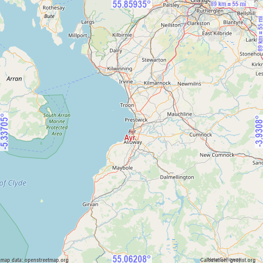
Ayr GPS coordinates[2]
55° 27' 45.828" North, 4° 38' 2.148" West
| Map corner | latitude | longitude |
|---|---|---|
| Upper-left | 55.85935°, | -5.33705° |
| Center: | 55.46273°, | -4.63393° |
| Lower-right: | 55.06208°, | -3.9308° |
| Map W x H: | 88.6×88.6 km | = 55.1×55.1mi |
| max Lat: | 60.39635° ⇑11.4% North |
| Ayr: | 55.46273° |
| min Lat: | ⇓88.6% South 34.60088° |
| min Long | Ayr | max Long |
| -7.64133° | -4.63393° | 32.95536° |
| W 5.6%⇐ | ⇒94.4% E |
Elevation
Elevation of Ayr is 13 m = 43 ft, and this is 59.9 m = 197 ft below average elevation for this country.
| Max E: |
515 m = 1690 ft | 88.2% |
| Avg. | 72.9 m = 239 ft | |
| Ayr | 13 m = 43 ft | |
Min E: |
-30 m = -98 ft | 11.8% |
See also: Ayr elevation on elevation.city.
Geographical zone
Ayr is located in North temperate zone (between Tropic of Cancer and the Arctic Circle). Distance of this North polar circle is 1234.3 km =767 mi to North.| Distance of | km | miles | from Ayr |
|---|---|---|---|
| North Pole | 3840.2 | 2386.2 | to North |
| Arctic Circle | 1234.3 | 767 | to North |
| Tropic Cancer | 3561 | 2212.7 | to South |
| Equator | 6166.9 | 3831.9 | to South |


Nearby cities:
15 places around Ayr: (largest is in red/bold)
• Annbank
7.2 km =4.5 mi,  78°
78°
• Coylton
7.5 km =4.7 mi,  105°
105°
• Dalrymple
7.7 km =4.8 mi,  159°
159°
• Drongan
11.7 km =7.3 mi, 105°
• Dundonald
13.2 km =8.2 mi,  10°
10°
• Hillhead
9 km =5.6 mi,  100°
100°
• Loans
9.8 km =6.1 mi,  3°
3°
• Maybole
12.3 km =7.6 mi,  193°
193°
• Monkton
6.2 km =3.9 mi,  24°
24°
• Mossblown
7.3 km =4.5 mi,  66°
66°
• Patna
13.6 km =8.5 mi,  143°
143°
• Prestwick
2.5 km =1.6 mi,  25°
25°
• Symington
11 km =6.8 mi, 25°
• Tarbolton
10.8 km =6.7 mi,  59°
59°
• Troon
9.2 km =5.7 mi,  348°
348°
Sources, notices
• [Note1] Compared only with cities in United Kingdom existing in our database
• [Src1] Map data: © OpenStreetMap contributors (CC-BY-SA)
• [Src2] Other city data from geonames.org with taken over terms of usage.
• [Src3] Geographical zone / Annual Mean Temperature by Robert A. Rohde @ Wikipedia
