Aberdeen geodata
Aberdeen (Scotland) is a seat of a second-order administrative division; located in United Kingdom in Europe/London (GMT+1) time zone. With population of 196,670 people, there are 39 cities with bigger population in this country. Compared to other cities in United Kingdom, 97.7% of cities are located further ↓South; 56.7% of cities are located further →East and 88.2% of cities have higher elevation than Aberdeen. Note1


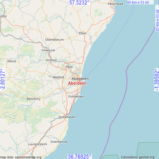
Aberdeen GPS coordinates[2]
57° 8' 37.284" North, 2° 5' 53.304" West
| Map corner | latitude | longitude |
|---|---|---|
| Upper-left | 57.5232°, | -2.80127° |
| Center: | 57.14369°, | -2.09814° |
| Lower-right: | 56.76025°, | -1.39502° |
| Map W x H: | 84.8×84.8 km | = 52.7×52.7mi |
| max Lat: | 60.39635° ⇑2.3% North |
| Aberdeen: | 57.14369° |
| min Lat: | ⇓97.7% South 34.60088° |
| min Long | Aberdeen | max Long |
| -7.64133° | -2.09814° | 32.95536° |
| W 43.3%⇐ | ⇒56.7% E |
Elevation
Elevation of Aberdeen is 13 m = 43 ft, and this is 59.9 m = 197 ft below average elevation for this country.
| Max E: |
515 m = 1690 ft | 88.2% |
| Avg. | 72.9 m = 239 ft | |
| Aberdeen | 13 m = 43 ft | |
Min E: |
-30 m = -98 ft | 11.8% |
See also: Aberdeen elevation on elevation.city.
Geographical zone
Aberdeen is located in North temperate zone (between Tropic of Cancer and the Arctic Circle). Distance of this North polar circle is 1047.4 km =650.8 mi to North.| Distance of | km | miles | from Aberdeen |
|---|---|---|---|
| North Pole | 3653.3 | 2270.1 | to North |
| Arctic Circle | 1047.4 | 650.8 | to North |
| Tropic Cancer | 3747.9 | 2328.8 | to South |
| Equator | 6353.8 | 3948.1 | to South |


Nearby cities:
15 places around Aberdeen: (largest is in red/bold)
• Balmedie
12.1 km =7.5 mi,  10°
10°
• Blackburn
13.3 km =8.3 mi,  300°
300°
• Cove
4.9 km =3 mi,  169°
169°
• Cults
5.1 km =3.2 mi,  234°
234°
• Drumoak
16.5 km =10.3 mi,  244°
244°
• Dyce
8.3 km =5.2 mi,  325°
325°
• Kingseat
13.7 km =8.5 mi,  344°
344°
• Kingswells
7.8 km =4.8 mi,  281°
281°
• Milltimber
9.7 km =6 mi, 243°
• Newmacher
14.6 km =9.1 mi, 339°
• Newtonhill
12.7 km =7.9 mi,  194°
194°
• Peterculter
11.3 km =7 mi, 244°
• Portlethen
8.5 km =5.3 mi, 194°
• Potterton
9.7 km =6 mi,  2°
2°
• Westhill
11 km =6.8 mi, 275°
Sources, notices
• [Note1] Compared only with cities in United Kingdom existing in our database
• [Src1] Map data: © OpenStreetMap contributors (CC-BY-SA)
• [Src2] Other city data from geonames.org with taken over terms of usage.
• [Src3] Geographical zone / Annual Mean Temperature by Robert A. Rohde @ Wikipedia
