Telford geodata
Telford (England) is a seat of a second-order administrative division; located in United Kingdom in Europe/London (GMT+1) time zone. With population of 147,980 people, there are 62 cities with bigger population in this country. Compared to other cities in United Kingdom, 54.6% of cities are located further ↓South; 64% of cities are located further →East and 92.4% of cities have lower elevation than Telford. Note1
Administrative division(s):
- Level 1: England
- Level 2: Telford and Wrekin
- Level 3: Lawley and Overdale


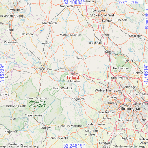
Telford GPS coordinates[2]
52° 40' 35.724" North, 2° 26' 57.336" West
| Map corner | latitude | longitude |
|---|---|---|
| Upper-left | 53.10083°, | -3.15239° |
| Center: | 52.67659°, | -2.44926° |
| Lower-right: | 52.24819°, | -1.74614° |
| Map W x H: | 94.8×94.8 km | = 58.9×58.9mi |
| max Lat: | 60.39635° ⇑45.4% North |
| Telford: | 52.67659° |
| min Lat: | ⇓54.6% South 34.60088° |
| min Long | Telford | max Long |
| -7.64133° | -2.44926° | 32.95536° |
| W 36%⇐ | ⇒64% E |
Elevation
Elevation of Telford is 163 m = 535 ft, and this is 90.1 m = 296 ft above average elevation for this country.
| Max E: |
515 m = 1690 ft | 7.6% |
| Telford | 163 m 535 ft | |
| Avg. | 72.9 m = 239 ft | |
Min E: |
-30 m = -98 ft | 92.4% |
See also: Telford elevation on elevation.city.
Geographical zone
Telford is located in North temperate zone (between Tropic of Cancer and the Arctic Circle). Distance of this North polar circle is 1544.1 km =959.5 mi to North.| Distance of | km | miles | from Telford |
|---|---|---|---|
| North Pole | 4150 | 2578.7 | to North |
| Arctic Circle | 1544.1 | 959.5 | to North |
| Tropic Cancer | 3251.2 | 2020.2 | to South |
| Equator | 5857.1 | 3639.4 | to South |


Nearby cities:
15 places around Telford: (largest is in red/bold)
• Broseley
7.4 km =4.6 mi,  197°
197°
• Edgmond
11.2 km =7 mi,  13°
13°
• Eyton upon the Weald Moors
7.8 km =4.8 mi,  324°
324°
• Hadley
3.5 km =2.2 mi, 318°
• Ironbridge
5.9 km =3.7 mi, 203°
• Lilleshall
7.1 km =4.4 mi,  25°
25°
• Madeley
4.9 km =3 mi,  167°
167°
• Newport
11.1 km =6.9 mi, 25°
• Oakengates
2 km =1.2 mi,  357°
357°
• Ryton
9.4 km =5.8 mi,  134°
134°
• Shifnal
5.2 km =3.2 mi,  97°
97°
• Tong
10.1 km =6.3 mi, 96°
• Wellington
5.2 km =3.2 mi,  299°
299°
• Withington
11.1 km =6.9 mi,  293°
293°
• Woodcote
10 km =6.2 mi,  51°
51°
Sources, notices
• [Note1] Compared only with cities in United Kingdom existing in our database
• [Src1] Map data: © OpenStreetMap contributors (CC-BY-SA)
• [Src2] Other city data from geonames.org with taken over terms of usage.
• [Src3] Geographical zone / Annual Mean Temperature by Robert A. Rohde @ Wikipedia
