Grange-over-Sands geodata
Grange-over-Sands (England) is a populated place; located in United Kingdom in Europe/London (GMT+1) time zone. With population of 4,788 people, there are 1674 cities with bigger population in this country. Compared to other cities in United Kingdom, 80.1% of cities are located further ↓South; 73.7% of cities are located further →East and 50.3% of cities have lower elevation than Grange-over-Sands. Note1
Administrative division(s):
- Level 1: England
- Level 2: Cumbria
- Level 3: South Lakeland District
- Level 4: Grange-Over-Sands


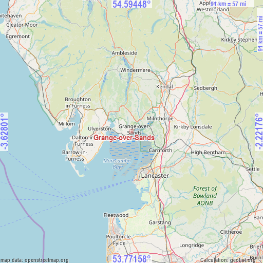
Grange-over-Sands GPS coordinates[2]
54° 11' 6.288" North, 2° 55' 29.568" West
| Map corner | latitude | longitude |
|---|---|---|
| Upper-left | 54.59448°, | -3.62801° |
| Center: | 54.18508°, | -2.92488° |
| Lower-right: | 53.77158°, | -2.22176° |
| Map W x H: | 91.5×91.5 km | = 56.9×56.9mi |
| max Lat: | 60.39635° ⇑19.9% North |
| Grange-over-Sands: | 54.18508° |
| min Lat: | ⇓80.1% South 34.60088° |
| min Long | Grange-over-San | max Long |
| -7.64133° | -2.92488° | 32.95536° |
| W 26.3%⇐ | ⇒73.7% E |
Elevation
Elevation of Grange-over-Sands is 61 m = 200 ft, and this is 11.9 m = 39 ft below average elevation for this country.
| Max E: |
515 m = 1690 ft | 49.7% |
| Avg. | 72.9 m = 239 ft | |
| Grange-over-Sands | 61 m = 200 ft | |
Min E: |
-30 m = -98 ft | 50.3% |
See also: United Kingdom elevation on elevation.city.
Geographical zone
Grange-over-Sands is located in North temperate zone (between Tropic of Cancer and the Arctic Circle). Distance of this North polar circle is 1376.4 km =855.3 mi to North.| Distance of | km | miles | from Grange-over-Sands |
|---|---|---|---|
| North Pole | 3982.2 | 2474.4 | to North |
| Arctic Circle | 1376.4 | 855.3 | to North |
| Tropic Cancer | 3418.9 | 2124.4 | to South |
| Equator | 6024.8 | 3743.6 | to South |


Nearby cities:
15 places around Grange-over-Sands: (largest is in red/bold)
• Arnside
6.2 km =3.9 mi,  72°
72°
• Backbarrow
8.8 km =5.5 mi,  332°
332°
• Bolton le Sands
12.8 km =8 mi,  140°
140°
• Carnforth
11.8 km =7.3 mi,  120°
120°
• Flookburgh
3.3 km =2.1 mi,  248°
248°
• Heversham
11.7 km =7.3 mi,  57°
57°
• Levens
12.9 km =8 mi,  43°
43°
• Lindale
4 km =2.5 mi,  27°
27°
• Milnthorpe
11.2 km =7 mi, 64°
• Morecambe
13.6 km =8.5 mi,  162°
162°
• Nether Kellet
13.9 km =8.6 mi,  128°
128°
• Silverdale
7.3 km =4.5 mi,  106°
106°
• Swarthmoor
12.5 km =7.8 mi,  269°
269°
• Ulverston
11.2 km =7 mi,  276°
276°
• Warton
11.3 km =7 mi, 111°
Sources, notices
• [Note1] Compared only with cities in United Kingdom existing in our database
• [Src1] Map data: © OpenStreetMap contributors (CC-BY-SA)
• [Src2] Other city data from geonames.org with taken over terms of usage.
• [Src3] Geographical zone / Annual Mean Temperature by Robert A. Rohde @ Wikipedia
