Bilsdale geodata
Bilsdale (England) is a populated locality; located in United Kingdom in Europe/London (GMT+1) time zone. With population of 1,841 people, there are 2750 cities with bigger population in this country. Compared to other cities in United Kingdom, 81.1% of cities are located further ↓South; 64.5% of cities are located further ←West and 99.6% of cities have lower elevation than Bilsdale. Note1
Administrative division(s):
- Level 1: England
- Level 2: North Yorkshire
- Level 3: Hambleton District
- Level 4: Bilsdale Midcable


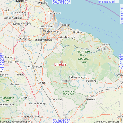
Bilsdale GPS coordinates[2]
54° 22' 24.816" North, 1° 7' 9.228" West
| Map corner | latitude | longitude |
|---|---|---|
| Upper-left | 54.78109°, | -1.82235° |
| Center: | 54.37356°, | -1.11923° |
| Lower-right: | 53.96195°, | -0.4161° |
| Map W x H: | 91.1×91.1 km | = 56.6×56.6mi |
| max Lat: | 60.39635° ⇑18.9% North |
| Bilsdale: | 54.37356° |
| min Lat: | ⇓81.1% South 34.60088° |
| min Long | Bilsdale | max Long |
| -7.64133° | -1.11923° | 32.95536° |
| W 64.5%⇐ | ⇒35.5% E |
Elevation
Elevation of Bilsdale is 300 m = 984 ft, and this is 227.1 m = 745 ft above average elevation for this country.
| Max E: |
515 m = 1690 ft | 0.40000000000001% |
| Bilsdale | 300 m 984 ft | |
| Avg. | 72.9 m = 239 ft | |
Min E: |
-30 m = -98 ft | 99.6% |
See also: United Kingdom elevation on elevation.city.
Geographical zone
Bilsdale is located in North temperate zone (between Tropic of Cancer and the Arctic Circle). Distance of this North polar circle is 1355.4 km =842.2 mi to North.| Distance of | km | miles | from Bilsdale |
|---|---|---|---|
| North Pole | 3961.3 | 2461.4 | to North |
| Arctic Circle | 1355.4 | 842.2 | to North |
| Tropic Cancer | 3439.9 | 2137.5 | to South |
| Equator | 6045.8 | 3756.7 | to South |


Nearby cities:
15 places around Bilsdale: (largest is in red/bold)
• Ampleforth
19.4 km =12.1 mi,  177°
177°
• Brompton
19.8 km =12.3 mi,  265°
265°
• Danby
17 km =10.6 mi,  52°
52°
• Great Ayton
13.2 km =8.2 mi,  355°
355°
• Great Broughton
8.6 km =5.3 mi,  343°
343°
• Guisborough
18.4 km =11.4 mi,  12°
12°
• Helmsley
14.8 km =9.2 mi,  164°
164°
• Ingleby Greenhow
8.5 km =5.3 mi, 5°
• Kirkbymoorside
16.7 km =10.4 mi,  133°
133°
• Kirklevington
18.6 km =11.6 mi,  310°
310°
• Nawton
15.5 km =9.6 mi,  147°
147°
• Nunthorpe
17.8 km =11.1 mi,  346°
346°
• Osmotherley
11.7 km =7.3 mi, 267°
• Stokesley
11.7 km =7.3 mi, 335°
• Swainby
10.5 km =6.5 mi,  294°
294°
Sources, notices
• [Note1] Compared only with cities in United Kingdom existing in our database
• [Src1] Map data: © OpenStreetMap contributors (CC-BY-SA)
• [Src2] Other city data from geonames.org with taken over terms of usage.
• [Src3] Geographical zone / Annual Mean Temperature by Robert A. Rohde @ Wikipedia
