Sutukung geodata
Sutukung (Lower River) is a populated place; located in Gambia in Africa/Banjul (GMT+0) time zone. With population of 1,506 people, there are 45 cities with bigger population in this country. Compared to other cities in Gambia, 51.2% of cities are located further ↓South; 54.5% of cities are located further ←West and 84.6% of cities have higher elevation than Sutukung. Note1


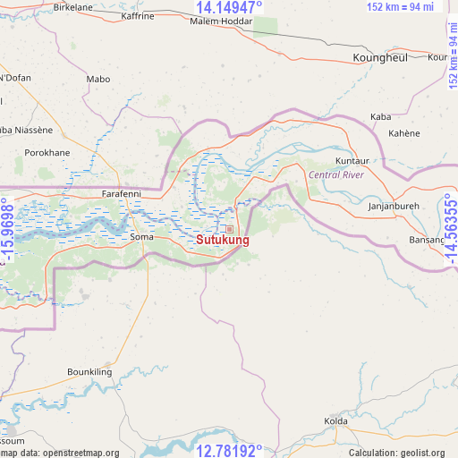
Sutukung GPS coordinates[2]
13° 28' 0.012" North, 15° 16' 0.012" West
| Map corner | latitude | longitude |
|---|---|---|
| Upper-left | 14.14947°, | -15.9698° |
| Center: | 13.46667°, | -15.26667° |
| Lower-right: | 12.78192°, | -14.56355° |
| Map W x H: | 152.1×152.1 km | = 94.5×94.5mi |
| max Lat: | 13.8° ⇑48.8% North |
| Sutukung: | 13.46667° |
| min Lat: | ⇓51.2% South 13.20194° |
| min Long | Sutukung | max Long |
| -16.73389° | -15.26667° | -13.85° |
| W 54.5%⇐ | ⇒45.5% E |
Elevation
Elevation of Sutukung is 11 m = 36 ft, and this is 10.1 m = 33 ft below average elevation for this country.
| Max E: |
49 m = 161 ft | 84.6% |
| Avg. | 21.1 m = 69 ft | |
| Sutukung | 11 m = 36 ft | |
Min E: |
1 m = 3 ft | 15.4% |
See also: Gambia elevation on elevation.city.
Geographical zone
Sutukung is located in North Torrid zone (between Equator and Tropic of Cancer). Distance of this Northern Tropic circle is 1108.6 km =688.9 mi to North.| Distance of | km | miles | from Sutukung |
|---|---|---|---|
| North Pole | 8509.7 | 5287.7 | to North |
| Arctic Circle | 5903.8 | 3668.5 | to North |
| Tropic Cancer | 1108.6 | 688.9 | to North |
| Equator | 1497.4 | 930.4 | to South |


Nearby cities:
15 places around Sutukung: (largest is in red/bold)
• Bambali
7.4 km =4.6 mi,  284°
284°
• Baro Kunda
1.9 km =1.2 mi,  0°
0°
• Buniadu
11.7 km =7.3 mi,  322°
322°
• Bureng
5.8 km =3.6 mi,  197°
197°
• Dankunku
12.4 km =7.7 mi,  334°
334°
• Dongoro Ba
9.4 km =5.8 mi,  191°
191°
• Jarreng
19 km =11.8 mi,  28°
28°
• Jassong
9.2 km =5.7 mi,  216°
216°
• Katamina
9.4 km =5.8 mi,  348°
348°
• Madina
4.1 km =2.5 mi, 25°
• Sambang
10.3 km =6.4 mi, 315°
• Sami
14.8 km =9.2 mi, 29°
• Sara Kunda
17.8 km =11.1 mi,  294°
294°
• Sukuta
10.3 km =6.4 mi,  44°
44°
• Wellingara Ba
15.5 km =9.6 mi,  248°
248°
Sources, notices
• [Note1] Compared only with cities in Gambia existing in our database
• [Src1] Map data: © OpenStreetMap contributors (CC-BY-SA)
• [Src2] Other city data from geonames.org with taken over terms of usage.
• [Src3] Geographical zone / Annual Mean Temperature by Robert A. Rohde @ Wikipedia
