Le Moule geodata
Le Moule (Guadeloupe) is a populated place; located in Guadeloupe in America/Guadeloupe (GMT-4) time zone. With population of 22,692 people, there are 5 cities with bigger population in this country. Compared to other cities in Guadeloupe, 83.3% of cities are located further ↓South; 87.5% of cities are located further ←West and 75% of cities have higher elevation than Le Moule. Note1
Administrative division(s):
- Level 1: Guadeloupe
- Level 2: Guadeloupe
- Level 3: Arrondissement de Pointe-à-Pitre
- Level 4: Le Moule


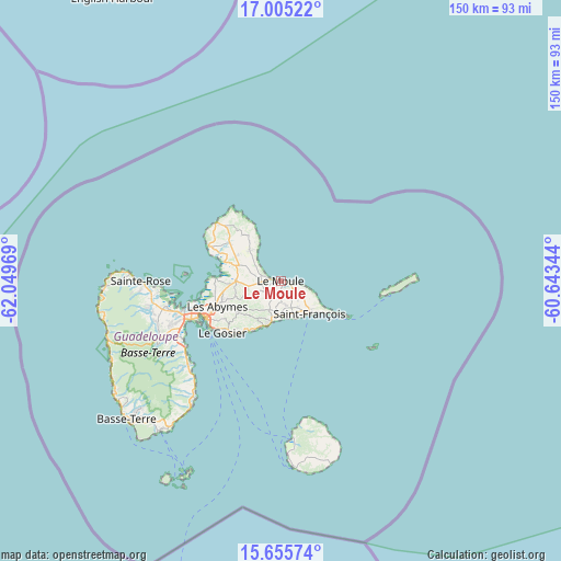
Le Moule GPS coordinates[2]
16° 19' 53.904" North, 61° 20' 47.616" West
| Map corner | latitude | longitude |
|---|---|---|
| Upper-left | 17.00522°, | -62.04969° |
| Center: | 16.33164°, | -61.34656° |
| Lower-right: | 15.65574°, | -60.64344° |
| Map W x H: | 150×150.1 km | = 93.2×93.3mi |
| max Lat: | 16.47239° ⇑16.7% North |
| Le Moule: | 16.33164° |
| min Lat: | ⇓83.3% South 15.84993° |
| min Long | Le Moule | max Long |
| -61.78917° | -61.34656° | -61.07375° |
| W 87.5%⇐ | ⇒12.5% E |
Elevation
Elevation of Le Moule is 8 m = 26 ft, and this is 41.2 m = 135 ft below average elevation for this country.
| Max E: |
462 m = 1516 ft | 75% |
| Avg. | 49.2 m = 161 ft | |
| Le Moule | 8 m = 26 ft | |
Min E: |
3 m = 10 ft | 25% |
See also: Guadeloupe elevation on elevation.city.
Geographical zone
Le Moule is located in North Torrid zone (between Equator and Tropic of Cancer). Distance of this Northern Tropic circle is 790 km =490.9 mi to North.| Distance of | km | miles | from Le Moule |
|---|---|---|---|
| North Pole | 8191.2 | 5089.8 | to North |
| Arctic Circle | 5585.3 | 3470.5 | to North |
| Tropic Cancer | 790 | 490.9 | to North |
| Equator | 1815.9 | 1128.3 | to South |


Nearby cities:
15 places around Le Moule: (largest is in red/bold)
• Anse-Bertrand
23.2 km =14.4 mi,  312°
312°
• Baie-Mahault
26.5 km =16.5 mi,  254°
254°
• Beauséjour
29.3 km =18.2 mi,  95°
95°
• Capesterre-Belle-Eau
39.5 km =24.5 mi,  216°
216°
• Lamentin
31.2 km =19.4 mi,  257°
257°
• Le Gosier
21 km =13 mi,  228°
228°
• Les Abymes
18.1 km =11.2 mi, 248°
• Petit-Bourg
30.4 km =18.9 mi,  239°
239°
• Petit-Canal
15.9 km =9.9 mi,  289°
289°
• Pointe-Noire
48.5 km =30.1 mi, 256°
• Pointe-à-Pitre
22.6 km =14 mi, 243°
• Port-Louis
21.8 km =13.5 mi,  295°
295°
• Saint-François
11.8 km =7.3 mi,  138°
138°
• Sainte-Anne
12.3 km =7.6 mi,  197°
197°
• Sainte-Rose
37.4 km =23.2 mi,  270°
270°
Sources, notices
• [Note1] Compared only with cities in Guadeloupe existing in our database
• [Src1] Map data: © OpenStreetMap contributors (CC-BY-SA)
• [Src2] Other city data from geonames.org with taken over terms of usage.
• [Src3] Geographical zone / Annual Mean Temperature by Robert A. Rohde @ Wikipedia
