Gourbeyre geodata
Gourbeyre (Guadeloupe) is a populated place; located in Guadeloupe in America/Guadeloupe (GMT-4) time zone. With population of 8,571 people, there are 14 cities with bigger population in this country. Compared to other cities in Guadeloupe, 87.5% of cities are located further ↑North; 70.8% of cities are located further →East and 95.8% of cities have lower elevation than Gourbeyre. Note1
Administrative division(s):
- Level 1: Guadeloupe
- Level 2: Guadeloupe
- Level 3: Arrondissement de la Basse-Terre
- Level 4: Gourbeyre


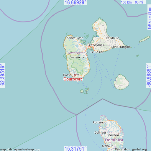
Gourbeyre GPS coordinates[2]
15° 59' 40.344" North, 61° 41' 31.308" West
| Map corner | latitude | longitude |
|---|---|---|
| Upper-left | 16.66929°, | -62.39516° |
| Center: | 15.99454°, | -61.69203° |
| Lower-right: | 15.31751°, | -60.98891° |
| Map W x H: | 150.3×150.3 km | = 93.4×93.4mi |
| max Lat: | 16.47239° ⇑87.5% North |
| Gourbeyre: | 15.99454° |
| min Lat: | ⇓12.5% South 15.84993° |
| min Long | Gourbeyre | max Long |
| -61.78917° | -61.69203° | -61.07375° |
| W 29.2%⇐ | ⇒70.8% E |
Elevation
Elevation of Gourbeyre is 339 m = 1112 ft, and this is 289.8 m = 951 ft above average elevation for this country.
| Max E: |
462 m = 1516 ft | 4.2% |
| Gourbeyre | 339 m 1112 ft | |
| Avg. | 49.2 m = 161 ft | |
Min E: |
3 m = 10 ft | 95.8% |
See also: Guadeloupe elevation on elevation.city.
Geographical zone
Gourbeyre is located in North Torrid zone (between Equator and Tropic of Cancer). Distance of this Northern Tropic circle is 827.5 km =514.2 mi to North.| Distance of | km | miles | from Gourbeyre |
|---|---|---|---|
| North Pole | 8228.6 | 5113 | to North |
| Arctic Circle | 5622.7 | 3493.8 | to North |
| Tropic Cancer | 827.5 | 514.2 | to North |
| Equator | 1778.4 | 1105 | to South |


Nearby cities:
15 places around Gourbeyre: (largest is in red/bold)
• Baie-Mahault
32.4 km =20.1 mi,  20°
20°
• Baillif
6.5 km =4 mi,  296°
296°
• Basse-Terre
4.3 km =2.7 mi,  273°
273°
• Bouillante
17.2 km =10.7 mi,  331°
331°
• Capesterre-Belle-Eau
14.8 km =9.2 mi,  67°
67°
• Lamentin
31.4 km =19.5 mi,  11°
11°
• Le Gosier
31.7 km =19.7 mi,  42°
42°
• Les Abymes
36.8 km =22.9 mi,  32°
32°
• Petit-Bourg
24.4 km =15.2 mi, 26°
• Petites Anses
16.9 km =10.5 mi,  162°
162°
• Pointe-Noire
28.4 km =17.6 mi,  338°
338°
• Pointe-à-Pitre
32.1 km =19.9 mi, 31°
• Saint-Claude
3.5 km =2.2 mi,  346°
346°
• Trois-Rivières
5.4 km =3.4 mi,  112°
112°
• Vieux-Habitants
10.7 km =6.6 mi,  311°
311°
Sources, notices
• [Note1] Compared only with cities in Guadeloupe existing in our database
• [Src1] Map data: © OpenStreetMap contributors (CC-BY-SA)
• [Src2] Other city data from geonames.org with taken over terms of usage.
• [Src3] Geographical zone / Annual Mean Temperature by Robert A. Rohde @ Wikipedia
