Argolikón geodata
Argolikón (Peloponnese) is a populated place; located in Greece in Europe/Athens (GMT+3) time zone. With population of 609 people, there are 1568 cities with bigger population in this country. Compared to other cities in Greece, 84.4% of cities are located further ↑North; 51.6% of cities are located further →East and 84.7% of cities have higher elevation than Argolikón. Note1


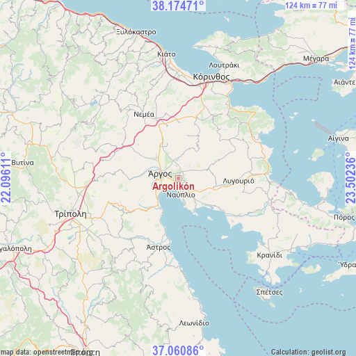
Argolikón GPS coordinates[2]
37° 37' 11.532" North, 22° 47' 57.228" East
| Map corner | latitude | longitude |
|---|---|---|
| Upper-left | 38.17471°, | 22.09611° |
| Center: | 37.61987°, | 22.79923° |
| Lower-right: | 37.06086°, | 23.50236° |
| Map W x H: | 123.8×123.8 km | = 76.9×76.9mi |
| max Lat: | 41.72048° ⇑84.4% North |
| Argolikón: | 37.61987° |
| min Lat: | ⇓15.6% South 34.8346° |
| min Long | Argolikón | max Long |
| 19.40494° | 22.79923° | 29.59361° |
| W 48.4%⇐ | ⇒51.6% E |
Elevation
Elevation of Argolikón is 13 m = 43 ft, and this is 155.9 m = 511 ft below average elevation for this country.
| Max E: |
1439 m = 4721 ft | 84.7% |
| Avg. | 168.9 m = 554 ft | |
| Argolikón | 13 m = 43 ft | |
Min E: |
0 m = 0 ft | 15.3% |
See also: Greece elevation on elevation.city.
Geographical zone
Argolikón is located in North temperate zone (between Tropic of Cancer and the Arctic Circle). Distance of this Northern Tropic circle is 1577 km =979.9 mi to South.| Distance of | km | miles | from Argolikón |
|---|---|---|---|
| North Pole | 5824.1 | 3618.9 | to North |
| Arctic Circle | 3218.2 | 1999.7 | to North |
| Tropic Cancer | 1577 | 979.9 | to South |
| Equator | 4182.9 | 2599.1 | to South |


Nearby cities:
15 places around Argolikón: (largest is in red/bold)
• Anífion
4.5 km =2.8 mi,  348°
348°
• Aria
6 km =3.7 mi,  148°
148°
• Ayía Triás
2 km =1.2 mi,  14°
14°
• Dhalamanára
2.6 km =1.6 mi,  266°
266°
• Lefkákia
8.6 km =5.3 mi,  140°
140°
• Láloukas
1.6 km =1 mi,  304°
304°
• Mánesis
5.1 km =3.2 mi,  27°
27°
• Náfplio
5.7 km =3.5 mi,  173°
173°
• Néa Kíos
5.9 km =3.7 mi,  236°
236°
• Néa Tírins
2.3 km =1.4 mi,  126°
126°
• Panarítis
2.5 km =1.6 mi,  59°
59°
• Poullakídha
3.5 km =2.2 mi,  21°
21°
• Árgos
6 km =3.7 mi,  284°
284°
• Áyios Adhrianós
4.7 km =2.9 mi,  118°
118°
• Ínachos
6.6 km =4.1 mi,  318°
318°
Sources, notices
• [Note1] Compared only with cities in Greece existing in our database
• [Src1] Map data: © OpenStreetMap contributors (CC-BY-SA)
• [Src2] Other city data from geonames.org with taken over terms of usage.
• [Src3] Geographical zone / Annual Mean Temperature by Robert A. Rohde @ Wikipedia
