Prgomet geodata
Prgomet (Split-Dalmatia) is a seat of a second-order administrative division; located in Croatia in Europe/Zagreb (GMT+2) time zone. In our database, there are 904 cities with bigger population. Compared to other cities in Croatia, 89.2% of cities are located further ↑North; 60.8% of cities are located further →East and 93% of cities have lower elevation than Prgomet. Note1


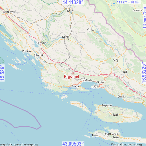
Prgomet GPS coordinates[2]
43° 36' 22.716" North, 16° 13' 44.832" East
| Map corner | latitude | longitude |
|---|---|---|
| Upper-left | 44.11328°, | 15.526° |
| Center: | 43.60631°, | 16.22912° |
| Lower-right: | 43.09503°, | 16.93225° |
| Map W x H: | 113.2×113.2 km | = 70.3×70.3mi |
| max Lat: | 46.52694° ⇑89.2% North |
| Prgomet: | 43.60631° |
| min Lat: | ⇓10.8% South 42.54972° |
| min Long | Prgomet | max Long |
| 13.52389° | 16.22912° | 19.37694° |
| W 39.2%⇐ | ⇒60.8% E |
Elevation
Elevation of Prgomet is 344 m = 1129 ft, and this is 190.7 m = 626 ft above average elevation for this country.
| Max E: |
827 m = 2713 ft | 7% |
| Prgomet | 344 m 1129 ft | |
| Avg. | 153.3 m = 503 ft | |
Min E: |
-1 m = -3 ft | 93% |
See also: Croatia elevation on elevation.city.
Geographical zone
Prgomet is located in North temperate zone (between Tropic of Cancer and the Arctic Circle). Distance of this Northern Tropic circle is 2242.6 km =1393.5 mi to South.| Distance of | km | miles | from Prgomet |
|---|---|---|---|
| North Pole | 5158.5 | 3205.3 | to North |
| Arctic Circle | 2552.6 | 1586.1 | to North |
| Tropic Cancer | 2242.6 | 1393.5 | to South |
| Equator | 4848.6 | 3012.8 | to South |


Nearby cities:
15 places around Prgomet: (largest is in red/bold)
• Donji Seget
10 km =6.2 mi,  178°
178°
• Kaštel Kambelovac
13.9 km =8.6 mi,  116°
116°
• Kaštel Lukšić
12.5 km =7.8 mi, 116°
• Kaštel Novi
10.5 km =6.5 mi,  126°
126°
• Kaštel Stari
11.6 km =7.2 mi, 122°
• Kaštel Štafilić
10.5 km =6.5 mi, 126°
• Lećevica
10.5 km =6.5 mi,  67°
67°
• Marina
14.2 km =8.8 mi,  224°
224°
• Mastrinka
11.1 km =6.9 mi,  159°
159°
• Okrug Gornji
12.7 km =7.9 mi,  166°
166°
• Plano
8 km =5 mi,  149°
149°
• Primorski Dolac
5.1 km =3.2 mi,  302°
302°
• Seget Vranjica
11.2 km =7 mi,  197°
197°
• Sitno Donje
11.8 km =7.3 mi,  318°
318°
• Trogir
10.6 km =6.6 mi, 170°
Sources, notices
• [Note1] Compared only with cities in Croatia existing in our database
• [Src1] Map data: © OpenStreetMap contributors (CC-BY-SA)
• [Src2] Other city data from geonames.org with taken over terms of usage.
• [Src3] Geographical zone / Annual Mean Temperature by Robert A. Rohde @ Wikipedia
