Opatija geodata
Opatija (Primorsko-Goranska) is a seat of a second-order administrative division; located in Croatia in Europe/Zagreb (GMT+2) time zone. With population of 7,888 people, there are 50 cities with bigger population in this country. Compared to other cities in Croatia, 56.9% of cities are located further ↑North; 94.9% of cities are located further →East and 85.6% of cities have higher elevation than Opatija. Note1


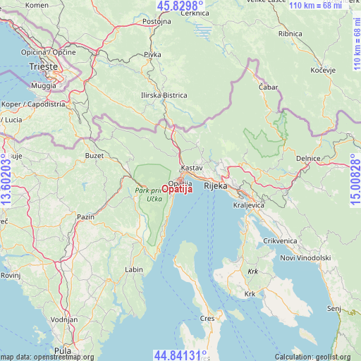
Opatija GPS coordinates[2]
45° 20' 15.756" North, 14° 18' 18.54" East
| Map corner | latitude | longitude |
|---|---|---|
| Upper-left | 45.8298°, | 13.60203° |
| Center: | 45.33771°, | 14.30515° |
| Lower-right: | 44.84131°, | 15.00828° |
| Map W x H: | 109.9×109.9 km | = 68.3×68.3mi |
| max Lat: | 46.52694° ⇑56.9% North |
| Opatija: | 45.33771° |
| min Lat: | ⇓43.1% South 42.54972° |
| min Long | Opatija | max Long |
| 13.52389° | 14.30515° | 19.37694° |
| W 5.1%⇐ | ⇒94.9% E |
Elevation
Elevation of Opatija is 59 m = 194 ft, and this is 94.3 m = 309 ft below average elevation for this country.
| Max E: |
827 m = 2713 ft | 85.6% |
| Avg. | 153.3 m = 503 ft | |
| Opatija | 59 m = 194 ft | |
Min E: |
-1 m = -3 ft | 14.4% |
See also: Croatia elevation on elevation.city.
Geographical zone
Opatija is located in North temperate zone (between Tropic of Cancer and the Arctic Circle). Distance of this North polar circle is 2360.1 km =1466.5 mi to North.| Distance of | km | miles | from Opatija |
|---|---|---|---|
| North Pole | 4966 | 3085.7 | to North |
| Arctic Circle | 2360.1 | 1466.5 | to North |
| Tropic Cancer | 2435.2 | 1513.2 | to South |
| Equator | 5041.1 | 3132.4 | to South |


Nearby cities:
15 places around Opatija: (largest is in red/bold)
• Drenova
9.9 km =6.2 mi,  82°
82°
• Jurdani
4.9 km =3 mi,  10°
10°
• Jušići
4.6 km =2.9 mi,  16°
16°
• Kastav
5.4 km =3.4 mi,  39°
39°
• Lovran
5.6 km =3.5 mi,  205°
205°
• Marinići
7.6 km =4.7 mi,  66°
66°
• Marčelji
9.2 km =5.7 mi,  45°
45°
• Matulji
3.1 km =1.9 mi,  30°
30°
• Mihotići
2.6 km =1.6 mi,  0°
0°
• Poljane
3.7 km =2.3 mi,  232°
232°
• Rijeka
10.8 km =6.7 mi,  96°
96°
• Rubeši
4.7 km =2.9 mi, 45°
• Rukavac
2.9 km =1.8 mi,  343°
343°
• Veprinac
2.3 km =1.4 mi,  263°
263°
• Viškovo
7.5 km =4.7 mi,  55°
55°
Sources, notices
• [Note1] Compared only with cities in Croatia existing in our database
• [Src1] Map data: © OpenStreetMap contributors (CC-BY-SA)
• [Src2] Other city data from geonames.org with taken over terms of usage.
• [Src3] Geographical zone / Annual Mean Temperature by Robert A. Rohde @ Wikipedia
