Dugopolje geodata
Dugopolje (Split-Dalmatia) is a seat of a second-order administrative division; located in Croatia in Europe/Zagreb (GMT+2) time zone. With population of 2,687 people, there are 160 cities with bigger population in this country. Compared to other cities in Croatia, 89.4% of cities are located further ↑North; 56.4% of cities are located further ←West and 89.1% of cities have lower elevation than Dugopolje. Note1


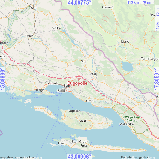
Dugopolje GPS coordinates[2]
43° 34' 50.016" North, 16° 36' 10.008" East
| Map corner | latitude | longitude |
|---|---|---|
| Upper-left | 44.08775°, | 15.89966° |
| Center: | 43.58056°, | 16.60278° |
| Lower-right: | 43.06906°, | 17.30591° |
| Map W x H: | 113.3×113.3 km | = 70.4×70.4mi |
| max Lat: | 46.52694° ⇑89.4% North |
| Dugopolje: | 43.58056° |
| min Lat: | ⇓10.6% South 42.54972° |
| min Long | Dugopolje | max Long |
| 13.52389° | 16.60278° | 19.37694° |
| W 56.4%⇐ | ⇒43.6% E |
Elevation
Elevation of Dugopolje is 281 m = 922 ft, and this is 127.7 m = 419 ft above average elevation for this country.
| Max E: |
827 m = 2713 ft | 10.9% |
| Dugopolje | 281 m 922 ft | |
| Avg. | 153.3 m = 503 ft | |
Min E: |
-1 m = -3 ft | 89.1% |
See also: Croatia elevation on elevation.city.
Geographical zone
Dugopolje is located in North temperate zone (between Tropic of Cancer and the Arctic Circle). Distance of this Northern Tropic circle is 2239.8 km =1391.7 mi to South.| Distance of | km | miles | from Dugopolje |
|---|---|---|---|
| North Pole | 5161.4 | 3207.1 | to North |
| Arctic Circle | 2555.5 | 1587.9 | to North |
| Tropic Cancer | 2239.8 | 1391.7 | to South |
| Equator | 4845.7 | 3011 | to South |


Nearby cities:
15 places around Dugopolje: (largest is in red/bold)
• Brnaze
11.7 km =7.3 mi,  18°
18°
• Greda
8.3 km =5.2 mi,  62°
62°
• Kamen
10.2 km =6.3 mi,  223°
223°
• Klis
7.1 km =4.4 mi,  250°
250°
• Košute
9.3 km =5.8 mi,  53°
53°
• Kučine
7.9 km =4.9 mi,  227°
227°
• Mravince
8.4 km =5.2 mi, 231°
• Podstrana
11.3 km =7 mi,  202°
202°
• Solin
9.8 km =6.1 mi,  244°
244°
• Srinjine
10.8 km =6.7 mi,  181°
181°
• Stobreč
10.8 km =6.7 mi, 216°
• Trilj
10.6 km =6.6 mi,  66°
66°
• Turjaci
9.4 km =5.8 mi,  34°
34°
• Čeline
7.4 km =4.6 mi,  339°
339°
• Žrnovnica
7.5 km =4.7 mi,  207°
207°
Sources, notices
• [Note1] Compared only with cities in Croatia existing in our database
• [Src1] Map data: © OpenStreetMap contributors (CC-BY-SA)
• [Src2] Other city data from geonames.org with taken over terms of usage.
• [Src3] Geographical zone / Annual Mean Temperature by Robert A. Rohde @ Wikipedia
