Belišće geodata
Belišće (Osječko-Baranjska) is a seat of a second-order administrative division; located in Croatia in Europe/Zagreb (GMT+2) time zone. With population of 7,232 people, there are 55 cities with bigger population in this country. Compared to other cities in Croatia, 63.2% of cities are located further ↓South; 87.8% of cities are located further ←West and 74.8% of cities have higher elevation than Belišće. Note1


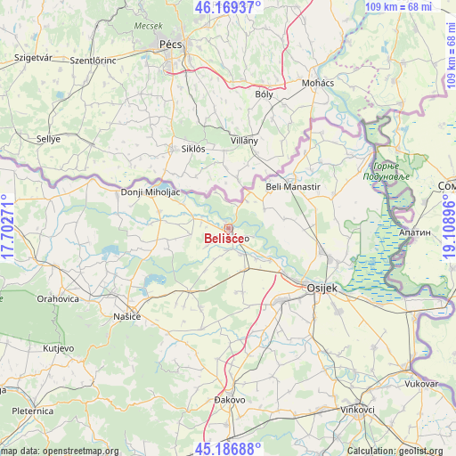
Belišće GPS coordinates[2]
45° 40' 49.008" North, 18° 24' 20.988" East
| Map corner | latitude | longitude |
|---|---|---|
| Upper-left | 46.16937°, | 17.70271° |
| Center: | 45.68028°, | 18.40583° |
| Lower-right: | 45.18688°, | 19.10896° |
| Map W x H: | 109.2×109.2 km | = 67.9×67.9mi |
| max Lat: | 46.52694° ⇑36.8% North |
| Belišće: | 45.68028° |
| min Lat: | ⇓63.2% South 42.54972° |
| min Long | Belišće | max Long |
| 13.52389° | 18.40583° | 19.37694° |
| W 87.8%⇐ | ⇒12.2% E |
Elevation
Elevation of Belišće is 89 m = 292 ft, and this is 64.3 m = 211 ft below average elevation for this country.
| Max E: |
827 m = 2713 ft | 74.8% |
| Avg. | 153.3 m = 503 ft | |
| Belišće | 89 m = 292 ft | |
Min E: |
-1 m = -3 ft | 25.2% |
See also: Croatia elevation on elevation.city.
Geographical zone
Belišće is located in North temperate zone (between Tropic of Cancer and the Arctic Circle). Distance of this North polar circle is 2322 km =1442.8 mi to North.| Distance of | km | miles | from Belišće |
|---|---|---|---|
| North Pole | 4927.9 | 3062.1 | to North |
| Arctic Circle | 2322 | 1442.8 | to North |
| Tropic Cancer | 2473.3 | 1536.8 | to South |
| Equator | 5079.2 | 3156.1 | to South |


Nearby cities:
15 places around Belišće: (largest is in red/bold)
• Baranjsko Petrovo Selo
9.8 km =6.1 mi,  30°
30°
• Bistrinci
1.4 km =0.9 mi,  336°
336°
• Bizovac
10.6 km =6.6 mi,  157°
157°
• Bolman
9.7 km =6 mi,  62°
62°
• Cret Bizovački
11.7 km =7.3 mi,  177°
177°
• Gat
6.9 km =4.3 mi,  294°
294°
• Harkanovci
11.5 km =7.1 mi,  209°
209°
• Ladimirevci
6.9 km =4.3 mi,  151°
151°
• Marjanci
9 km =5.6 mi,  260°
260°
• Nard
6.4 km =4 mi,  107°
107°
• Podgajci Podravski
11.8 km =7.3 mi,  297°
297°
• Satnica
9.8 km =6.1 mi,  138°
138°
• Valpovo
2.4 km =1.5 mi, 155°
• Veliškovci
6.6 km =4.1 mi,  280°
280°
• Črnkovci
9.1 km =5.7 mi, 289°
Sources, notices
• [Note1] Compared only with cities in Croatia existing in our database
• [Src1] Map data: © OpenStreetMap contributors (CC-BY-SA)
• [Src2] Other city data from geonames.org with taken over terms of usage.
• [Src3] Geographical zone / Annual Mean Temperature by Robert A. Rohde @ Wikipedia
