Madžarevo geodata
Madžarevo (Varaždinska) is a populated place; located in Croatia in Europe/Zagreb (GMT+2) time zone. With population of 910 people, there are 517 cities with bigger population in this country. Compared to other cities in Croatia, 87.4% of cities are located further ↓South; 57.4% of cities are located further →East and 80.4% of cities have lower elevation than Madžarevo. Note1


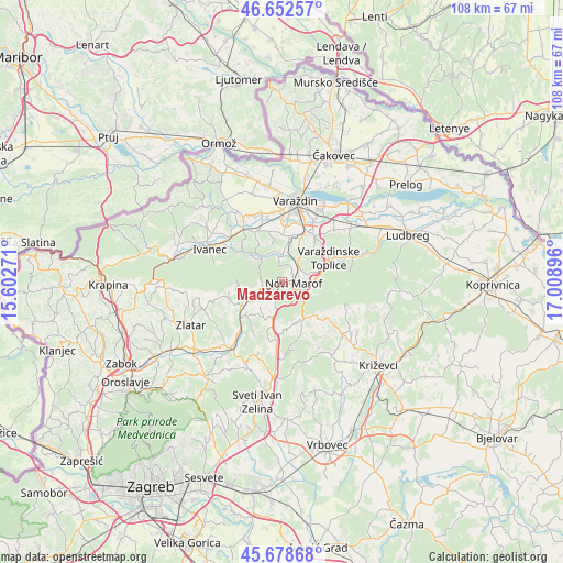
Madžarevo GPS coordinates[2]
46° 10' 4.008" North, 16° 18' 20.988" East
| Map corner | latitude | longitude |
|---|---|---|
| Upper-left | 46.65257°, | 15.60271° |
| Center: | 46.16778°, | 16.30583° |
| Lower-right: | 45.67868°, | 17.00896° |
| Map W x H: | 108.3×108.3 km | = 67.3×67.3mi |
| max Lat: | 46.52694° ⇑12.6% North |
| Madžarevo: | 46.16778° |
| min Lat: | ⇓87.4% South 42.54972° |
| min Long | Madžarevo | max Long |
| 13.52389° | 16.30583° | 19.37694° |
| W 42.6%⇐ | ⇒57.4% E |
Elevation
Elevation of Madžarevo is 205 m = 673 ft, and this is 51.7 m = 170 ft above average elevation for this country.
| Max E: |
827 m = 2713 ft | 19.6% |
| Madžarevo | 205 m 673 ft | |
| Avg. | 153.3 m = 503 ft | |
Min E: |
-1 m = -3 ft | 80.4% |
See also: Croatia elevation on elevation.city.
Geographical zone
Madžarevo is located in North temperate zone (between Tropic of Cancer and the Arctic Circle). Distance of this North polar circle is 2267.8 km =1409.1 mi to North.| Distance of | km | miles | from Madžarevo |
|---|---|---|---|
| North Pole | 4873.7 | 3028.4 | to North |
| Arctic Circle | 2267.8 | 1409.1 | to North |
| Tropic Cancer | 2527.5 | 1570.5 | to South |
| Equator | 5133.4 | 3189.7 | to South |


Nearby cities:
15 places around Madžarevo: (largest is in red/bold)
• Beletinec
5.7 km =3.5 mi,  1°
1°
• Beretinec
9.2 km =5.7 mi,  357°
357°
• Breznički Hum
7.1 km =4.4 mi,  198°
198°
• Budinšćina
8.8 km =5.5 mi,  240°
240°
• Donje Makojišće
2.3 km =1.4 mi,  225°
225°
• Hrašćina
8.6 km =5.3 mi,  224°
224°
• Ključ
4.1 km =2.5 mi,  88°
88°
• Ljubešćica
6 km =3.7 mi, 91°
• Možđenec
3.9 km =2.4 mi,  120°
120°
• Novi Marof
2 km =1.2 mi,  109°
109°
• Podevčevo
4.7 km =2.9 mi,  349°
349°
• Remetinec
2.6 km =1.6 mi,  40°
40°
• Sveti Ilija
8.9 km =5.5 mi,  9°
9°
• Varaždinske Toplice
9.9 km =6.2 mi,  62°
62°
• Visoko
8.7 km =5.4 mi,  170°
170°
Sources, notices
• [Note1] Compared only with cities in Croatia existing in our database
• [Src1] Map data: © OpenStreetMap contributors (CC-BY-SA)
• [Src2] Other city data from geonames.org with taken over terms of usage.
• [Src3] Geographical zone / Annual Mean Temperature by Robert A. Rohde @ Wikipedia
