Ózd geodata
Ózd (Borsod-Abaúj-Zemplén) is a seat of a second-order administrative division; located in Hungary in Europe/Budapest (GMT+2) time zone. With population of 38,476 people, there are 46 cities with bigger population in this country. Compared to other cities in Hungary, 96.4% of cities are located further ↓South; 68.2% of cities are located further ←West and 85.5% of cities have lower elevation than Ózd. Note1


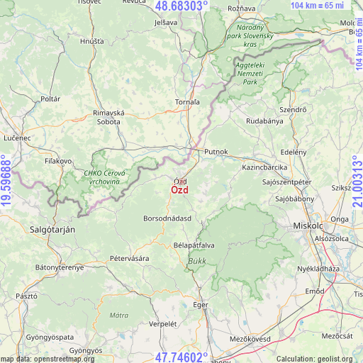
Ózd GPS coordinates[2]
48° 13' 0.012" North, 20° 18' 0" East
| Map corner | latitude | longitude |
|---|---|---|
| Upper-left | 48.68303°, | 19.59688° |
| Center: | 48.21667°, | 20.3° |
| Lower-right: | 47.74602°, | 21.00313° |
| Map W x H: | 104.2×104.2 km | = 64.7×64.7mi |
| max Lat: | 48.46667° ⇑3.6% North |
| Ózd: | 48.21667° |
| min Lat: | ⇓96.4% South 45.79108° |
| min Long | Ózd | max Long |
| 16.27358° | 20.3° | 22.68096° |
| W 68.2%⇐ | ⇒31.8% E |
Elevation
Elevation of Ózd is 175 m = 574 ft, and this is 45.3 m = 149 ft above average elevation for this country.
| Max E: |
444 m = 1457 ft | 14.5% |
| Ózd | 175 m 574 ft | |
| Avg. | 129.7 m = 426 ft | |
Min E: |
71 m = 233 ft | 85.5% |
See also: Hungary elevation on elevation.city.
Geographical zone
Ózd is located in North temperate zone (between Tropic of Cancer and the Arctic Circle). Distance of this North polar circle is 2040 km =1267.6 mi to North.| Distance of | km | miles | from Ózd |
|---|---|---|---|
| North Pole | 4645.9 | 2886.8 | to North |
| Arctic Circle | 2040 | 1267.6 | to North |
| Tropic Cancer | 2755.3 | 1712.1 | to South |
| Equator | 5361.2 | 3331.3 | to South |


Nearby cities:
15 places around Ózd: (largest is in red/bold)
• Arló
4.5 km =2.8 mi,  213°
213°
• Borsodnádasd
11.7 km =7.3 mi,  198°
198°
• Bélapátfalva
19.2 km =11.9 mi,  165°
165°
• Farkaslyuk
3.9 km =2.4 mi,  161°
161°
• Felsőtárkány
29.1 km =18.1 mi, 162°
• Izsófalva
28.7 km =17.8 mi,  71°
71°
• Járdánháza
8.3 km =5.2 mi, 206°
• Kazincbarcika
25 km =15.5 mi,  81°
81°
• Mályinka
16 km =9.9 mi,  115°
115°
• Múcsony
28.9 km =18 mi, 78°
• Putnok
13.5 km =8.4 mi,  46°
46°
• Pétervására
26.7 km =16.6 mi, 213°
• Sajókaza
22.2 km =13.8 mi, 70°
• Szilvásvárad
14.9 km =9.3 mi,  150°
150°
• Tarnalelesz
20.5 km =12.7 mi, 205°
Sources, notices
• [Note1] Compared only with cities in Hungary existing in our database
• [Src1] Map data: © OpenStreetMap contributors (CC-BY-SA)
• [Src2] Other city data from geonames.org with taken over terms of usage.
• [Src3] Geographical zone / Annual Mean Temperature by Robert A. Rohde @ Wikipedia
