Mezőkövesd geodata
Mezőkövesd (Borsod-Abaúj-Zemplén) is a seat of a second-order administrative division; located in Hungary in Europe/Budapest (GMT+2) time zone. With population of 17,701 people, there are 98 cities with bigger population in this country. Compared to other cities in Hungary, 78.3% of cities are located further ↓South; 72.6% of cities are located further ←West and 51.5% of cities have lower elevation than Mezőkövesd. Note1


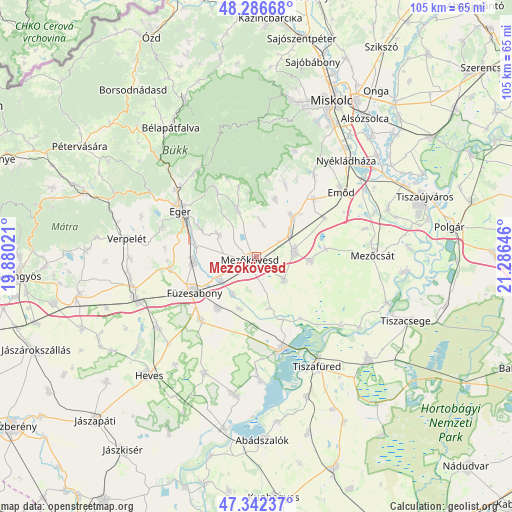
Mezőkövesd GPS coordinates[2]
47° 49' 0.012" North, 20° 34' 59.988" East
| Map corner | latitude | longitude |
|---|---|---|
| Upper-left | 48.28668°, | 19.88021° |
| Center: | 47.81667°, | 20.58333° |
| Lower-right: | 47.34237°, | 21.28646° |
| Map W x H: | 105×105 km | = 65.2×65.2mi |
| max Lat: | 48.46667° ⇑21.7% North |
| Mezőkövesd: | 47.81667° |
| min Lat: | ⇓78.3% South 45.79108° |
| min Long | Mezőkövesd | max Long |
| 16.27358° | 20.58333° | 22.68096° |
| W 72.6%⇐ | ⇒27.4% E |
Elevation
Elevation of Mezőkövesd is 117 m = 384 ft, and this is 12.7 m = 42 ft below average elevation for this country.
| Max E: |
444 m = 1457 ft | 48.5% |
| Avg. | 129.7 m = 426 ft | |
| Mezőkövesd | 117 m = 384 ft | |
Min E: |
71 m = 233 ft | 51.5% |
See also: Hungary elevation on elevation.city.
Geographical zone
Mezőkövesd is located in North temperate zone (between Tropic of Cancer and the Arctic Circle). Distance of this North polar circle is 2084.5 km =1295.2 mi to North.| Distance of | km | miles | from Mezőkövesd |
|---|---|---|---|
| North Pole | 4690.3 | 2914.4 | to North |
| Arctic Circle | 2084.5 | 1295.2 | to North |
| Tropic Cancer | 2710.8 | 1684.4 | to South |
| Equator | 5316.7 | 3303.6 | to South |


Nearby cities:
15 places around Mezőkövesd: (largest is in red/bold)
• Andornaktálya
13 km =8.1 mi,  286°
286°
• Besenyőtelek
17.1 km =10.6 mi,  220°
220°
• Bogács
10 km =6.2 mi,  338°
338°
• Csincse
15.9 km =9.9 mi,  60°
60°
• Eger
18.4 km =11.4 mi,  301°
301°
• Egerszalók
19.5 km =12.1 mi, 286°
• Füzesabony
14.5 km =9 mi,  239°
239°
• Kerecsend
17.5 km =10.9 mi,  263°
263°
• Maklár
12.6 km =7.8 mi, 261°
• Mezőkeresztes
8.9 km =5.5 mi,  77°
77°
• Ostoros
12.5 km =7.8 mi, 296°
• Poroszló
19.6 km =12.2 mi,  161°
161°
• Szentistván
8.3 km =5.2 mi,  131°
131°
• Szihalom
9.3 km =5.8 mi,  233°
233°
• Sály
16.1 km =10 mi,  22°
22°
Sources, notices
• [Note1] Compared only with cities in Hungary existing in our database
• [Src1] Map data: © OpenStreetMap contributors (CC-BY-SA)
• [Src2] Other city data from geonames.org with taken over terms of usage.
• [Src3] Geographical zone / Annual Mean Temperature by Robert A. Rohde @ Wikipedia
