Mád geodata
Mád (Borsod-Abaúj-Zemplén) is a populated place; located in Hungary in Europe/Budapest (GMT+2) time zone. With population of 2,589 people, there are 596 cities with bigger population in this country. Compared to other cities in Hungary, 95.7% of cities are located further ↓South; 85.6% of cities are located further ←West and 80.2% of cities have lower elevation than Mád. Note1


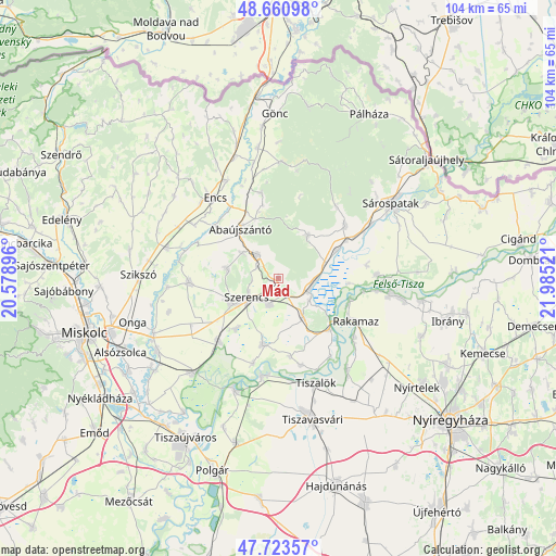
Mád GPS coordinates[2]
48° 11' 39.912" North, 21° 16' 55.488" East
| Map corner | latitude | longitude |
|---|---|---|
| Upper-left | 48.66098°, | 20.57896° |
| Center: | 48.19442°, | 21.28208° |
| Lower-right: | 47.72357°, | 21.98521° |
| Map W x H: | 104.2×104.2 km | = 64.7×64.7mi |
| max Lat: | 48.46667° ⇑4.3% North |
| Mád: | 48.19442° |
| min Lat: | ⇓95.7% South 45.79108° |
| min Long | Mád | max Long |
| 16.27358° | 21.28208° | 22.68096° |
| W 85.6%⇐ | ⇒14.4% E |
Elevation
Elevation of Mád is 158 m = 518 ft, and this is 28.3 m = 93 ft above average elevation for this country.
| Max E: |
444 m = 1457 ft | 19.8% |
| Mád | 158 m 518 ft | |
| Avg. | 129.7 m = 426 ft | |
Min E: |
71 m = 233 ft | 80.2% |
See also: Hungary elevation on elevation.city.
Geographical zone
Mád is located in North temperate zone (between Tropic of Cancer and the Arctic Circle). Distance of this North polar circle is 2042.5 km =1269.2 mi to North.| Distance of | km | miles | from Mád |
|---|---|---|---|
| North Pole | 4648.3 | 2888.3 | to North |
| Arctic Circle | 2042.5 | 1269.2 | to North |
| Tropic Cancer | 2752.8 | 1710.5 | to South |
| Equator | 5358.7 | 3329.7 | to South |


Nearby cities:
15 places around Mád: (largest is in red/bold)
• Abaújszántó
11.6 km =7.2 mi,  328°
328°
• Bekecs
8.8 km =5.5 mi,  236°
236°
• Megyaszó
17.2 km =10.7 mi,  265°
265°
• Mezőzombor
5.1 km =3.2 mi,  193°
193°
• Monok
9.9 km =6.2 mi,  280°
280°
• Olaszliszka
12.8 km =8 mi,  61°
61°
• Prügy
12.6 km =7.8 mi, 190°
• Rakamaz
15.6 km =9.7 mi,  120°
120°
• Szerencs
6.6 km =4.1 mi,  234°
234°
• Taktaharkány
16.6 km =10.3 mi,  221°
221°
• Taktaszada
11.3 km =7 mi, 220°
• Tarcal
8.5 km =5.3 mi,  143°
143°
• Tokaj
13.2 km =8.2 mi,  130°
130°
• Tolcsva
15.9 km =9.9 mi,  51°
51°
• Tállya
5.6 km =3.5 mi,  320°
320°
Sources, notices
• [Note1] Compared only with cities in Hungary existing in our database
• [Src1] Map data: © OpenStreetMap contributors (CC-BY-SA)
• [Src2] Other city data from geonames.org with taken over terms of usage.
• [Src3] Geographical zone / Annual Mean Temperature by Robert A. Rohde @ Wikipedia
