Bucsa geodata
Bucsa (Bekes) is a populated place; located in Hungary in Europe/Budapest (GMT+2) time zone. With population of 2,479 people, there are 622 cities with bigger population in this country. Compared to other cities in Hungary, 61.7% of cities are located further ↑North; 80.2% of cities are located further ←West and 93.3% of cities have higher elevation than Bucsa. Note1


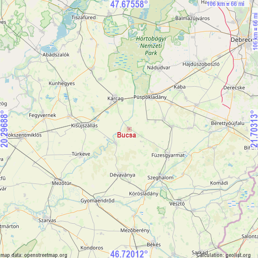
Bucsa GPS coordinates[2]
47° 12' 0" North, 21° 0' 0" East
| Map corner | latitude | longitude |
|---|---|---|
| Upper-left | 47.67558°, | 20.29688° |
| Center: | 47.2°, | 21° |
| Lower-right: | 46.72012°, | 21.70313° |
| Map W x H: | 106.2×106.2 km | = 66×66mi |
| max Lat: | 48.46667° ⇑61.7% North |
| Bucsa: | 47.2° |
| min Lat: | ⇓38.3% South 45.79108° |
| min Long | Bucsa | max Long |
| 16.27358° | 21° | 22.68096° |
| W 80.2%⇐ | ⇒19.8% E |
Elevation
Elevation of Bucsa is 85 m = 279 ft, and this is 44.7 m = 147 ft below average elevation for this country.
| Max E: |
444 m = 1457 ft | 93.3% |
| Avg. | 129.7 m = 426 ft | |
| Bucsa | 85 m = 279 ft | |
Min E: |
71 m = 233 ft | 6.7% |
See also: Hungary elevation on elevation.city.
Geographical zone
Bucsa is located in North temperate zone (between Tropic of Cancer and the Arctic Circle). Distance of this North polar circle is 2153 km =1337.8 mi to North.| Distance of | km | miles | from Bucsa |
|---|---|---|---|
| North Pole | 4758.9 | 2957 | to North |
| Arctic Circle | 2153 | 1337.8 | to North |
| Tropic Cancer | 2642.2 | 1641.8 | to South |
| Equator | 5248.1 | 3261 | to South |


Nearby cities:
15 places around Bucsa: (largest is in red/bold)
• Biharnagybajom
17.7 km =11 mi,  83°
83°
• Báránd
20.8 km =12.9 mi,  57°
57°
• Dévaványa
18.7 km =11.6 mi,  187°
187°
• Füzesgyarmat
19.8 km =12.3 mi,  124°
124°
• Kaba
27.1 km =16.8 mi,  52°
52°
• Karcag
13.9 km =8.6 mi,  338°
338°
• Kenderes
24.5 km =15.2 mi,  283°
283°
• Kisújszállás
17.7 km =11 mi, 276°
• Körösladány
26.7 km =16.6 mi,  166°
166°
• Nagyrábé
25.2 km =15.7 mi,  90°
90°
• Nádudvar
27.2 km =16.9 mi,  27°
27°
• Püspökladány
15.7 km =9.8 mi, 34°
• Szeghalom
22.4 km =13.9 mi,  145°
145°
• Sárrétudvari
15.6 km =9.7 mi, 76°
• Túrkeve
21.9 km =13.6 mi,  239°
239°
Sources, notices
• [Note1] Compared only with cities in Hungary existing in our database
• [Src1] Map data: © OpenStreetMap contributors (CC-BY-SA)
• [Src2] Other city data from geonames.org with taken over terms of usage.
• [Src3] Geographical zone / Annual Mean Temperature by Robert A. Rohde @ Wikipedia
