Gogolatar geodata
Gogolatar (East Java) is a seat of a fourth-order administrative division; located in Indonesia in Asia/Jakarta (GMT+7) time zone. In our database, there are 407 cities with bigger population. Compared to other cities in Indonesia, 64.6% of cities are located further ↑North; 52.3% of cities are located further ←West and 68.9% of cities have lower elevation than Gogolatar. Note1


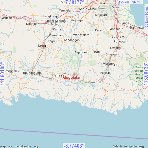
Gogolatar GPS coordinates[2]
8° 4' 42.6" South, 112° 18' 15.12" East
| Map corner | latitude | longitude |
|---|---|---|
| Upper-left | -7.38177°, | 111.60108° |
| Center: | -8.0785°, | 112.3042° |
| Lower-right: | -8.77403°, | 113.00733° |
| Map W x H: | 154.8×154.8 km | = 96.2×96.2mi |
| max Lat: | 5.88969° ⇑64.6% North |
| Gogolatar: | -8.0785° |
| min Lat: | ⇓35.4% South -10.934° |
| min Long | Gogolatar | max Long |
| 95.1345° | 112.3042° | 140.9419° |
| W 52.3%⇐ | ⇒47.7% E |
Elevation
Elevation of Gogolatar is 278 m = 912 ft, and this is 48.3 m = 158 ft above average elevation for this country.
| Max E: |
3185 m = 10449 ft | 31.1% |
| Gogolatar | 278 m 912 ft | |
| Avg. | 229.7 m = 754 ft | |
Min E: |
-1 m = -3 ft | 68.9% |
See also: Indonesia elevation on elevation.city.
Geographical zone
Gogolatar is located in South Torrid zone (between Equator and Tropic of Capricorn). Distance of Equator is 898.2 km =558.1 mi to North.| Distance of | km | miles | from Gogolatar |
|---|---|---|---|
| Equator | 898.2 | 558.1 | to North |
| Tropic Capricorn | 1707.7 | 1061.1 | to South |
| Antarctic Circle | 6502.9 | 4040.7 | to South |
| South Pole | 9108.8 | 5659.9 | to South |


Nearby cities:
15 places around Gogolatar: (largest is in red/bold)
• Beru
1.9 km =1.2 mi,  120°
120°
• Gandusari
3.6 km =2.2 mi,  357°
357°
• Gogosuket
1.6 km =1 mi,  221°
221°
• Jajar
1.1 km =0.7 mi,  304°
304°
• Kamulan
1.5 km =0.9 mi,  258°
258°
• Klemunan
4 km =2.5 mi, 123°
• Kotes
3.3 km =2.1 mi,  319°
319°
• Pandean
3.1 km =1.9 mi, 121°
• Plumbangan
4 km =2.5 mi,  86°
86°
• Sanan
2.6 km =1.6 mi, 297°
• Sragi
3.9 km =2.4 mi,  189°
189°
• Talun
2.5 km =1.6 mi,  237°
237°
• Tambakan
2.5 km =1.6 mi,  344°
344°
• Tembalang
3.5 km =2.2 mi,  74°
74°
• Wlingi
3 km =1.9 mi, 88°
Sources, notices
• [Note1] Compared only with cities in Indonesia existing in our database
• [Src1] Map data: © OpenStreetMap contributors (CC-BY-SA)
• [Src2] Other city data from geonames.org with taken over terms of usage.
• [Src3] Geographical zone / Annual Mean Temperature by Robert A. Rohde @ Wikipedia
