Windu geodata
Windu (East Java) is a seat of a fourth-order administrative division; located in Indonesia in Asia/Jakarta (GMT+7) time zone. In our database, there are 407 cities with bigger population. Compared to other cities in Indonesia, 64.3% of cities are located further ↓South; 54.8% of cities are located further ←West and 95.5% of cities have higher elevation than Windu. Note1


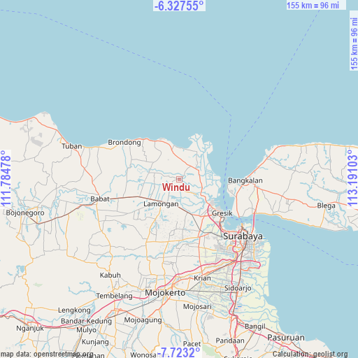
Windu GPS coordinates[2]
7° 1' 33.24" South, 112° 29' 16.44" East
| Map corner | latitude | longitude |
|---|---|---|
| Upper-left | -6.32755°, | 111.78478° |
| Center: | -7.0259°, | 112.4879° |
| Lower-right: | -7.7232°, | 113.19103° |
| Map W x H: | 155.2×155.2 km | = 96.4×96.4mi |
| max Lat: | 5.88969° ⇑35.7% North |
| Windu: | -7.0259° |
| min Lat: | ⇓64.3% South -10.934° |
| min Long | Windu | max Long |
| 95.1345° | 112.4879° | 140.9419° |
| W 54.8%⇐ | ⇒45.2% E |
Elevation
Elevation of Windu is 7 m = 23 ft, and this is 222.7 m = 731 ft below average elevation for this country.
| Max E: |
3185 m = 10449 ft | 95.5% |
| Avg. | 229.7 m = 754 ft | |
| Windu | 7 m = 23 ft | |
Min E: |
-1 m = -3 ft | 4.5% |
See also: Indonesia elevation on elevation.city.
Geographical zone
Windu is located in South Torrid zone (between Equator and Tropic of Capricorn). Distance of Equator is 781.2 km =485.4 mi to North.| Distance of | km | miles | from Windu |
|---|---|---|---|
| Equator | 781.2 | 485.4 | to North |
| Tropic Capricorn | 1824.7 | 1133.8 | to South |
| Antarctic Circle | 6620 | 4113.5 | to South |
| South Pole | 9225.9 | 5732.7 | to South |


Nearby cities:
15 places around Windu: (largest is in red/bold)
• Babakbawo
4.1 km =2.5 mi,  358°
358°
• Banjaranyar
3.3 km =2.1 mi,  298°
298°
• Baron
4.1 km =2.5 mi,  290°
290°
• Baturono
2.6 km =1.6 mi,  209°
209°
• Calan
3.6 km =2.2 mi,  225°
225°
• Gopaan
3.7 km =2.3 mi,  42°
42°
• Gupakan
3.7 km =2.3 mi, 38°
• Jrebeng
3.3 km =2.1 mi,  314°
314°
• Kalimati
2.3 km =1.4 mi,  34°
34°
• Kebon
2.4 km =1.5 mi, 228°
• Magok
3.1 km =1.9 mi,  242°
242°
• Prioso Barat
2.6 km =1.6 mi,  178°
178°
• Sambopinggir
1 km =0.6 mi, 291°
• Sembungan Kidul
3.1 km =1.9 mi,  45°
45°
• Watangan
1.3 km =0.8 mi,  341°
341°
Sources, notices
• [Note1] Compared only with cities in Indonesia existing in our database
• [Src1] Map data: © OpenStreetMap contributors (CC-BY-SA)
• [Src2] Other city data from geonames.org with taken over terms of usage.
• [Src3] Geographical zone / Annual Mean Temperature by Robert A. Rohde @ Wikipedia
