Tanjung geodata
Tanjung (East Java) is a seat of a fourth-order administrative division; located in Indonesia in Asia/Jakarta (GMT+7) time zone. In our database, there are 407 cities with bigger population. Compared to other cities in Indonesia, 65.6% of cities are located further ↑North; 59.6% of cities are located further ←West and 64.3% of cities have lower elevation than Tanjung. Note1


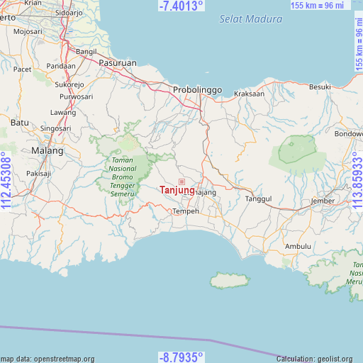
Tanjung GPS coordinates[2]
8° 5' 52.8" South, 113° 9' 22.32" East
| Map corner | latitude | longitude |
|---|---|---|
| Upper-left | -7.4013°, | 112.45308° |
| Center: | -8.098°, | 113.1562° |
| Lower-right: | -8.7935°, | 113.85933° |
| Map W x H: | 154.8×154.8 km | = 96.2×96.2mi |
| max Lat: | 5.88969° ⇑65.6% North |
| Tanjung: | -8.098° |
| min Lat: | ⇓34.4% South -10.934° |
| min Long | Tanjung | max Long |
| 95.1345° | 113.1562° | 140.9419° |
| W 59.6%⇐ | ⇒40.4% E |
Elevation
Elevation of Tanjung is 213 m = 699 ft, and this is 16.7 m = 55 ft below average elevation for this country.
| Max E: |
3185 m = 10449 ft | 35.7% |
| Avg. | 229.7 m = 754 ft | |
| Tanjung | 213 m = 699 ft | |
Min E: |
-1 m = -3 ft | 64.3% |
See also: Indonesia elevation on elevation.city.
Geographical zone
Tanjung is located in South Torrid zone (between Equator and Tropic of Capricorn). Distance of Equator is 900.4 km =559.5 mi to North.| Distance of | km | miles | from Tanjung |
|---|---|---|---|
| Equator | 900.4 | 559.5 | to North |
| Tropic Capricorn | 1705.5 | 1059.7 | to South |
| Antarctic Circle | 6500.8 | 4039.4 | to South |
| South Pole | 9106.6 | 5658.6 | to South |


Nearby cities:
15 places around Tanjung: (largest is in red/bold)
• Gasri
5.2 km =3.2 mi,  247°
247°
• Kajaran
4.1 km =2.5 mi,  69°
69°
• Krajan
2.4 km =1.5 mi,  17°
17°
• Krajan
3 km =1.9 mi,  155°
155°
• Krajan
3.8 km =2.4 mi,  231°
231°
• Krajan
4.7 km =2.9 mi,  61°
61°
• Krajan
5.4 km =3.4 mi,  110°
110°
• Krajan Satu
3.4 km =2.1 mi,  89°
89°
• Krajanpagowan
5.2 km =3.2 mi, 227°
• Pakel
4.9 km =3 mi,  320°
320°
• Perjuangan
5.3 km =3.3 mi,  147°
147°
• Purwosari
3.6 km =2.2 mi,  194°
194°
• Selokambang
5.1 km =3.2 mi,  167°
167°
• Sidomakmur
4.8 km =3 mi,  344°
344°
• Wonoayu
3.4 km =2.1 mi,  314°
314°
Sources, notices
• [Note1] Compared only with cities in Indonesia existing in our database
• [Src1] Map data: © OpenStreetMap contributors (CC-BY-SA)
• [Src2] Other city data from geonames.org with taken over terms of usage.
• [Src3] Geographical zone / Annual Mean Temperature by Robert A. Rohde @ Wikipedia
