Pringalot geodata
Pringalot (Bali) is a seat of a fourth-order administrative division; located in Indonesia in Asia/Makassar (GMT+8) time zone. In our database, there are 407 cities with bigger population. Compared to other cities in Indonesia, 81% of cities are located further ↑North; 74.6% of cities are located further ←West and 86.4% of cities have lower elevation than Pringalot. Note1


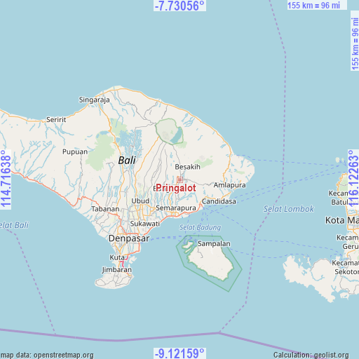
Pringalot GPS coordinates[2]
8° 25' 36.12" South, 115° 25' 10.2" East
| Map corner | latitude | longitude |
|---|---|---|
| Upper-left | -7.73056°, | 114.71638° |
| Center: | -8.4267°, | 115.4195° |
| Lower-right: | -9.12159°, | 116.12263° |
| Map W x H: | 154.7×154.7 km | = 96.1×96.1mi |
| max Lat: | 5.88969° ⇑81% North |
| Pringalot: | -8.4267° |
| min Lat: | ⇓19% South -10.934° |
| min Long | Pringalot | max Long |
| 95.1345° | 115.4195° | 140.9419° |
| W 74.6%⇐ | ⇒25.4% E |
Elevation
Elevation of Pringalot is 544 m = 1785 ft, and this is 314.3 m = 1031 ft above average elevation for this country.
| Max E: |
3185 m = 10449 ft | 13.6% |
| Pringalot | 544 m 1785 ft | |
| Avg. | 229.7 m = 754 ft | |
Min E: |
-1 m = -3 ft | 86.4% |
See also: Indonesia elevation on elevation.city.
Geographical zone
Pringalot is located in South Torrid zone (between Equator and Tropic of Capricorn). Distance of Equator is 937 km =582.2 mi to North.| Distance of | km | miles | from Pringalot |
|---|---|---|---|
| Equator | 937 | 582.2 | to North |
| Tropic Capricorn | 1669 | 1037.1 | to South |
| Antarctic Circle | 6464.2 | 4016.7 | to South |
| South Pole | 9070.1 | 5635.9 | to South |


Nearby cities:
15 places around Pringalot: (largest is in red/bold)
• Banjar Bangbang
2.8 km =1.7 mi,  218°
218°
• Banjar Besakih Kangin
6 km =3.7 mi,  29°
29°
• Banjar Gede
2.8 km =1.7 mi,  89°
89°
• Banjar Jehem Kaja
4.9 km =3 mi,  254°
254°
• Banjar Karangsuung Kaja
2.5 km =1.6 mi,  288°
288°
• Banjar Metra Tengah
4.4 km =2.7 mi,  299°
299°
• Banjar Pempatan
5.2 km =3.2 mi,  358°
358°
• Banjar Penida Kaja
3.8 km =2.4 mi,  258°
258°
• Banjar Pesaban Kawan
5.1 km =3.2 mi,  200°
200°
• Banjar Sidakaria
5.4 km =3.4 mi,  143°
143°
• Banjar Tengah
4.6 km =2.9 mi,  213°
213°
• Menanga
1.9 km =1.2 mi,  5°
5°
• Sangkangunung
3.8 km =2.4 mi,  155°
155°
• Tembuku
4.8 km =3 mi,  233°
233°
• Umasari Kauh
4.9 km =3 mi,  101°
101°
Sources, notices
• [Note1] Compared only with cities in Indonesia existing in our database
• [Src1] Map data: © OpenStreetMap contributors (CC-BY-SA)
• [Src2] Other city data from geonames.org with taken over terms of usage.
• [Src3] Geographical zone / Annual Mean Temperature by Robert A. Rohde @ Wikipedia
