Banjar Wangsian geodata
Banjar Wangsian (Bali) is a religious populated place; located in Indonesia in Asia/Makassar (GMT+8) time zone. With population of 2,353 people, there are 393 cities with bigger population in this country. Compared to other cities in Indonesia, 83.2% of cities are located further ↑North; 74.6% of cities are located further ←West and 64.3% of cities have lower elevation than Banjar Wangsian. Note1


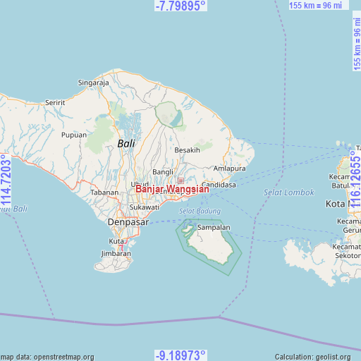
Banjar Wangsian GPS coordinates[2]
8° 29' 41.892" South, 115° 25' 24.312" East
| Map corner | latitude | longitude |
|---|---|---|
| Upper-left | -7.79895°, | 114.7203° |
| Center: | -8.49497°, | 115.42342° |
| Lower-right: | -9.18973°, | 116.12655° |
| Map W x H: | 154.6×154.6 km | = 96.1×96.1mi |
| max Lat: | 5.88969° ⇑83.2% North |
| Banjar Wangsian: | -8.49497° |
| min Lat: | ⇓16.8% South -10.934° |
| min Long | Banjar Wangsian | max Long |
| 95.1345° | 115.42342° | 140.9419° |
| W 74.6%⇐ | ⇒25.4% E |
Elevation
Elevation of Banjar Wangsian is 212 m = 696 ft, and this is 17.7 m = 58 ft below average elevation for this country.
| Max E: |
3185 m = 10449 ft | 35.7% |
| Avg. | 229.7 m = 754 ft | |
| Banjar Wangsian | 212 m = 696 ft | |
Min E: |
-1 m = -3 ft | 64.3% |
See also: Indonesia elevation on elevation.city.
Geographical zone
Banjar Wangsian is located in South Torrid zone (between Equator and Tropic of Capricorn). Distance of Equator is 944.6 km =586.9 mi to North.| Distance of | km | miles | from Banjar Wangsian |
|---|---|---|---|
| Equator | 944.6 | 586.9 | to North |
| Tropic Capricorn | 1661.4 | 1032.3 | to South |
| Antarctic Circle | 6456.6 | 4011.9 | to South |
| South Pole | 9062.5 | 5631.2 | to South |


Nearby cities:
15 places around Banjar Wangsian: (largest is in red/bold)
• Banjar Kaleran
3.9 km =2.4 mi,  240°
240°
• Banjar Kaleran
4.6 km =2.9 mi,  290°
290°
• Banjar Kanginan
4.4 km =2.7 mi,  191°
191°
• Banjar Kawan
4 km =2.5 mi,  127°
127°
• Banjar Lebah
4.6 km =2.9 mi,  203°
203°
• Banjar Pasek
4.8 km =3 mi,  251°
251°
• Banjar Pekandelan
3.4 km =2.1 mi,  226°
226°
• Banjar Pesaban Kawan
3.6 km =2.2 mi,  321°
321°
• Banjar Selat
2.2 km =1.4 mi,  259°
259°
• Banjar Sidakaria
4.3 km =2.7 mi,  40°
40°
• Banjar Tangkup Anyar
0.9 km =0.6 mi, 255°
• Banjar Tengah
2.1 km =1.3 mi,  274°
274°
• Kangin
3.8 km =2.4 mi,  277°
277°
• Sangkangunung
4.3 km =2.7 mi,  15°
15°
• Sidemen
2.7 km =1.7 mi,  63°
63°
Sources, notices
• [Note1] Compared only with cities in Indonesia existing in our database
• [Src1] Map data: © OpenStreetMap contributors (CC-BY-SA)
• [Src2] Other city data from geonames.org with taken over terms of usage.
• [Src3] Geographical zone / Annual Mean Temperature by Robert A. Rohde @ Wikipedia
