Dawan geodata
Dawan (Bali) is a seat of a fourth-order administrative division; located in Indonesia in Asia/Makassar (GMT+8) time zone. In our database, there are 407 cities with bigger population. Compared to other cities in Indonesia, 84.9% of cities are located further ↑North; 74.7% of cities are located further ←West and 72.7% of cities have higher elevation than Dawan. Note1


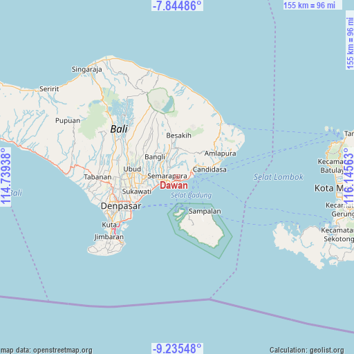
Dawan GPS coordinates[2]
8° 32' 26.88" South, 115° 26' 33" East
| Map corner | latitude | longitude |
|---|---|---|
| Upper-left | -7.84486°, | 114.73938° |
| Center: | -8.5408°, | 115.4425° |
| Lower-right: | -9.23548°, | 116.14563° |
| Map W x H: | 154.6×154.6 km | = 96.1×96.1mi |
| max Lat: | 5.88969° ⇑84.9% North |
| Dawan: | -8.5408° |
| min Lat: | ⇓15.1% South -10.934° |
| min Long | Dawan | max Long |
| 95.1345° | 115.4425° | 140.9419° |
| W 74.7%⇐ | ⇒25.3% E |
Elevation
Elevation of Dawan is 28 m = 92 ft, and this is 201.7 m = 662 ft below average elevation for this country.
| Max E: |
3185 m = 10449 ft | 72.7% |
| Avg. | 229.7 m = 754 ft | |
| Dawan | 28 m = 92 ft | |
Min E: |
-1 m = -3 ft | 27.3% |
See also: Indonesia elevation on elevation.city.
Geographical zone
Dawan is located in South Torrid zone (between Equator and Tropic of Capricorn). Distance of Equator is 949.6 km =590.1 mi to North.| Distance of | km | miles | from Dawan |
|---|---|---|---|
| Equator | 949.6 | 590.1 | to North |
| Tropic Capricorn | 1656.3 | 1029.2 | to South |
| Antarctic Circle | 6451.5 | 4008.8 | to South |
| South Pole | 9057.4 | 5628 | to South |


Nearby cities:
15 places around Dawan: (largest is in red/bold)
• Banjar Jabon
3.1 km =1.9 mi,  274°
274°
• Banjar Kampungislamkusamba
2.6 km =1.6 mi,  158°
158°
• Banjar Kanginan
2.4 km =1.5 mi,  118°
118°
• Banjar Kanginan
3.1 km =1.9 mi,  285°
285°
• Banjar Kawan
2.8 km =1.7 mi,  22°
22°
• Banjar Kawan
4.3 km =2.7 mi,  219°
219°
• Banjar Lebah
4.1 km =2.5 mi,  282°
282°
• Banjar Nyamping
2.1 km =1.3 mi,  262°
262°
• Banjar Pancingan
2.4 km =1.5 mi, 155°
• Banjar Pegatepan
4.2 km =2.6 mi,  249°
249°
• Banjar Peken
2.9 km =1.8 mi,  235°
235°
• Banjar Tengah
0.4 km =0.2 mi,  38°
38°
• Banjar Ulumsul
2.8 km =1.7 mi, 264°
• Semarapura
4.5 km =2.8 mi, 278°
• Tubanan
3.9 km =2.4 mi, 251°
Sources, notices
• [Note1] Compared only with cities in Indonesia existing in our database
• [Src1] Map data: © OpenStreetMap contributors (CC-BY-SA)
• [Src2] Other city data from geonames.org with taken over terms of usage.
• [Src3] Geographical zone / Annual Mean Temperature by Robert A. Rohde @ Wikipedia
