Bedugul geodata
Bedugul (Bali) is a populated place; located in Indonesia in Asia/Makassar (GMT+8) time zone. With population of 20,000 people, there are 370 cities with bigger population in this country. Compared to other cities in Indonesia, 81.8% of cities are located further ↑North; 75.4% of cities are located further ←West and 59.1% of cities have lower elevation than Bedugul. Note1


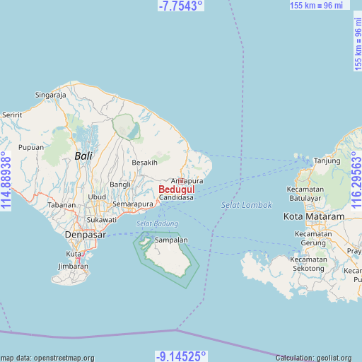
Bedugul GPS coordinates[2]
8° 27' 1.44" South, 115° 35' 33" East
| Map corner | latitude | longitude |
|---|---|---|
| Upper-left | -7.7543°, | 114.88938° |
| Center: | -8.4504°, | 115.5925° |
| Lower-right: | -9.14525°, | 116.29563° |
| Map W x H: | 154.7×154.7 km | = 96.1×96.1mi |
| max Lat: | 5.88969° ⇑81.8% North |
| Bedugul: | -8.4504° |
| min Lat: | ⇓18.2% South -10.934° |
| min Long | Bedugul | max Long |
| 95.1345° | 115.5925° | 140.9419° |
| W 75.4%⇐ | ⇒24.6% E |
Elevation
Elevation of Bedugul is 155 m = 509 ft, and this is 74.7 m = 245 ft below average elevation for this country.
| Max E: |
3185 m = 10449 ft | 40.9% |
| Avg. | 229.7 m = 754 ft | |
| Bedugul | 155 m = 509 ft | |
Min E: |
-1 m = -3 ft | 59.1% |
See also: Indonesia elevation on elevation.city.
Geographical zone
Bedugul is located in South Torrid zone (between Equator and Tropic of Capricorn). Distance of Equator is 939.6 km =583.8 mi to North.| Distance of | km | miles | from Bedugul |
|---|---|---|---|
| Equator | 939.6 | 583.8 | to North |
| Tropic Capricorn | 1666.3 | 1035.4 | to South |
| Antarctic Circle | 6461.6 | 4015.1 | to South |
| South Pole | 9067.5 | 5634.3 | to South |


Nearby cities:
15 places around Bedugul: (largest is in red/bold)
• Amlapura
2.7 km =1.7 mi,  89°
89°
• Amlapura city
1.5 km =0.9 mi,  82°
82°
• Banjar Ababi
5 km =3.1 mi,  350°
350°
• Banjar Beji
1.4 km =0.9 mi,  232°
232°
• Banjar Budakeling
3.4 km =2.1 mi,  317°
317°
• Banjar Bugbug
4.3 km =2.7 mi,  178°
178°
• Banjar Danginsema
2.6 km =1.6 mi, 90°
• Banjar Desa Tengah
3.4 km =2.1 mi,  289°
289°
• Banjar Genteng
1.1 km =0.7 mi,  122°
122°
• Banjar Pegeringsingan
4 km =2.5 mi,  224°
224°
• Banjar Timbrah
3 km =1.9 mi,  170°
170°
• Bebandem
3.7 km =2.3 mi, 289°
• Subagan
1.5 km =0.9 mi, 89°
• Tiyingtali Kelod
5 km =3.1 mi,  30°
30°
• Tumbukebon
3.5 km =2.2 mi, 80°
Sources, notices
• [Note1] Compared only with cities in Indonesia existing in our database
• [Src1] Map data: © OpenStreetMap contributors (CC-BY-SA)
• [Src2] Other city data from geonames.org with taken over terms of usage.
• [Src3] Geographical zone / Annual Mean Temperature by Robert A. Rohde @ Wikipedia
