Jawa geodata
Jawa (East Nusa Tenggara) is a seat of a fourth-order administrative division; located in Indonesia in Asia/Makassar (GMT+8) time zone. In our database, there are 407 cities with bigger population. Compared to other cities in Indonesia, 85.7% of cities are located further ↑North; 84.7% of cities are located further ←West and 96.8% of cities have lower elevation than Jawa. Note1


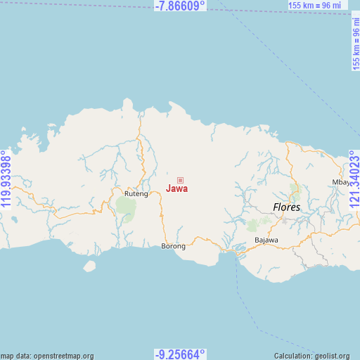
Jawa GPS coordinates[2]
8° 33' 43.2" South, 120° 38' 13.56" East
| Map corner | latitude | longitude |
|---|---|---|
| Upper-left | -7.86609°, | 119.93398° |
| Center: | -8.562°, | 120.6371° |
| Lower-right: | -9.25664°, | 121.34023° |
| Map W x H: | 154.6×154.6 km | = 96.1×96.1mi |
| max Lat: | 5.88969° ⇑85.7% North |
| Jawa: | -8.562° |
| min Lat: | ⇓14.3% South -10.934° |
| min Long | Jawa | max Long |
| 95.1345° | 120.6371° | 140.9419° |
| W 84.7%⇐ | ⇒15.3% E |
Elevation
Elevation of Jawa is 936 m = 3071 ft, and this is 706.3 m = 2317 ft above average elevation for this country.
| Max E: |
3185 m = 10449 ft | 3.2% |
| Jawa | 936 m 3071 ft | |
| Avg. | 229.7 m = 754 ft | |
Min E: |
-1 m = -3 ft | 96.8% |
See also: Indonesia elevation on elevation.city.
Geographical zone
Jawa is located in South Torrid zone (between Equator and Tropic of Capricorn). Distance of Equator is 952 km =591.5 mi to North.| Distance of | km | miles | from Jawa |
|---|---|---|---|
| Equator | 952 | 591.5 | to North |
| Tropic Capricorn | 1653.9 | 1027.7 | to South |
| Antarctic Circle | 6449.2 | 4007.3 | to South |
| South Pole | 9055.1 | 5626.6 | to South |


Nearby cities:
15 places around Jawa: (largest is in red/bold)
• Biting
3.9 km =2.4 mi,  184°
184°
• Buti
10.1 km =6.3 mi,  48°
48°
• Lengkoajang
7.6 km =4.7 mi,  37°
37°
• Lurut
10.4 km =6.5 mi,  166°
166°
• Mombok
10.9 km =6.8 mi,  69°
69°
• Necak
8.1 km =5 mi,  345°
345°
• Ngkiong
2.3 km =1.4 mi,  105°
105°
• Ngkodal
8.9 km =5.5 mi,  92°
92°
• Ngkolong
8.8 km =5.5 mi,  82°
82°
• Ntaram
7.3 km =4.5 mi,  58°
58°
• Rado
10.5 km =6.5 mi,  20°
20°
• Reweng
7 km =4.3 mi,  6°
6°
• Teber
11.5 km =7.1 mi,  204°
204°
• Waling
9.4 km =5.8 mi, 179°
• Watunggong
4.6 km =2.9 mi, 60°
Sources, notices
• [Note1] Compared only with cities in Indonesia existing in our database
• [Src1] Map data: © OpenStreetMap contributors (CC-BY-SA)
• [Src2] Other city data from geonames.org with taken over terms of usage.
• [Src3] Geographical zone / Annual Mean Temperature by Robert A. Rohde @ Wikipedia
