Jepang Satu geodata
Jepang Satu (Central Java) is a seat of a fourth-order administrative division; located in Indonesia in Asia/Jakarta (GMT+7) time zone. In our database, there are 407 cities with bigger population. Compared to other cities in Indonesia, 65% of cities are located further ↓South; 59.8% of cities are located further →East and 50.3% of cities have higher elevation than Jepang Satu. Note1


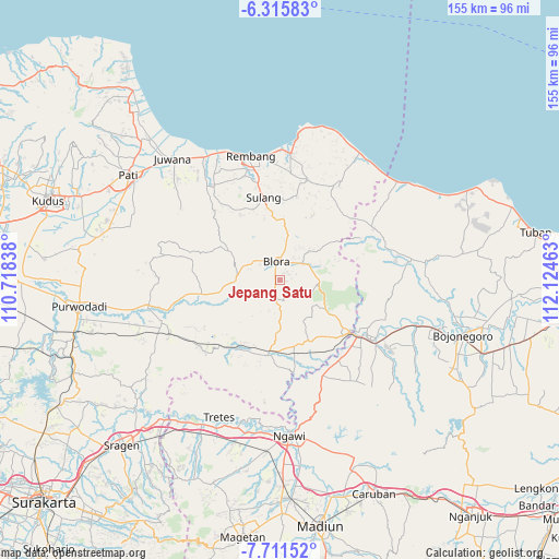
Jepang Satu GPS coordinates[2]
7° 0' 51.12" South, 111° 25' 17.4" East
| Map corner | latitude | longitude |
|---|---|---|
| Upper-left | -6.31583°, | 110.71838° |
| Center: | -7.0142°, | 111.4215° |
| Lower-right: | -7.71152°, | 112.12463° |
| Map W x H: | 155.2×155.2 km | = 96.4×96.4mi |
| max Lat: | 5.88969° ⇑35% North |
| Jepang Satu: | -7.0142° |
| min Lat: | ⇓65% South -10.934° |
| min Long | Jepang Satu | max Long |
| 95.1345° | 111.4215° | 140.9419° |
| W 40.2%⇐ | ⇒59.8% E |
Elevation
Elevation of Jepang Satu is 101 m = 331 ft, and this is 128.7 m = 422 ft below average elevation for this country.
| Max E: |
3185 m = 10449 ft | 50.3% |
| Avg. | 229.7 m = 754 ft | |
| Jepang Satu | 101 m = 331 ft | |
Min E: |
-1 m = -3 ft | 49.7% |
See also: Indonesia elevation on elevation.city.
Geographical zone
Jepang Satu is located in South Torrid zone (between Equator and Tropic of Capricorn). Distance of Equator is 779.9 km =484.6 mi to North.| Distance of | km | miles | from Jepang Satu |
|---|---|---|---|
| Equator | 779.9 | 484.6 | to North |
| Tropic Capricorn | 1826 | 1134.6 | to South |
| Antarctic Circle | 6621.3 | 4114.3 | to South |
| South Pole | 9227.2 | 5733.5 | to South |


Nearby cities:
15 places around Jepang Satu: (largest is in red/bold)
• Badong
1.9 km =1.2 mi,  304°
304°
• Bangeran
2.3 km =1.4 mi,  336°
336°
• Beran
4.1 km =2.5 mi, 342°
• Boto
3.7 km =2.3 mi,  287°
287°
• Dengok
3 km =1.9 mi,  42°
42°
• Jetis
4.4 km =2.7 mi, 343°
• Jomblang
2.1 km =1.3 mi,  102°
102°
• Karangnongko
4 km =2.5 mi,  318°
318°
• Kedungjenar
4.3 km =2.7 mi,  359°
359°
• Klopoduwur
2 km =1.2 mi,  223°
223°
• Mlangsen
4.5 km =2.8 mi,  351°
351°
• Ngablak
3.9 km =2.4 mi,  262°
262°
• Ngampon
0.9 km =0.6 mi,  64°
64°
• Nglego
3.1 km =1.9 mi, 61°
• Pelem
2.2 km =1.4 mi,  33°
33°
Sources, notices
• [Note1] Compared only with cities in Indonesia existing in our database
• [Src1] Map data: © OpenStreetMap contributors (CC-BY-SA)
• [Src2] Other city data from geonames.org with taken over terms of usage.
• [Src3] Geographical zone / Annual Mean Temperature by Robert A. Rohde @ Wikipedia
