Kromot geodata
Kromot (East Java) is a seat of a fourth-order administrative division; located in Indonesia in Asia/Jakarta (GMT+7) time zone. In our database, there are 407 cities with bigger population. Compared to other cities in Indonesia, 62.9% of cities are located further ↑North; 60.9% of cities are located further ←West and 60.7% of cities have lower elevation than Kromot. Note1


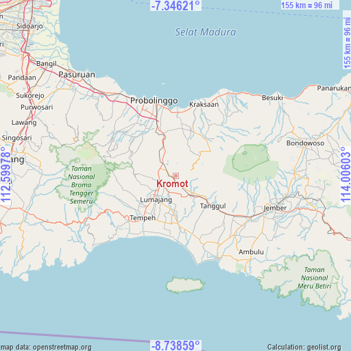
Kromot GPS coordinates[2]
8° 2' 34.8" South, 113° 18' 10.44" East
| Map corner | latitude | longitude |
|---|---|---|
| Upper-left | -7.34621°, | 112.59978° |
| Center: | -8.043°, | 113.3029° |
| Lower-right: | -8.73859°, | 114.00603° |
| Map W x H: | 154.8×154.8 km | = 96.2×96.2mi |
| max Lat: | 5.88969° ⇑62.9% North |
| Kromot: | -8.043° |
| min Lat: | ⇓37.1% South -10.934° |
| min Long | Kromot | max Long |
| 95.1345° | 113.3029° | 140.9419° |
| W 60.9%⇐ | ⇒39.1% E |
Elevation
Elevation of Kromot is 172 m = 564 ft, and this is 57.7 m = 189 ft below average elevation for this country.
| Max E: |
3185 m = 10449 ft | 39.3% |
| Avg. | 229.7 m = 754 ft | |
| Kromot | 172 m = 564 ft | |
Min E: |
-1 m = -3 ft | 60.7% |
See also: Indonesia elevation on elevation.city.
Geographical zone
Kromot is located in South Torrid zone (between Equator and Tropic of Capricorn). Distance of Equator is 894.3 km =555.7 mi to North.| Distance of | km | miles | from Kromot |
|---|---|---|---|
| Equator | 894.3 | 555.7 | to North |
| Tropic Capricorn | 1711.6 | 1063.5 | to South |
| Antarctic Circle | 6506.9 | 4043.2 | to South |
| South Pole | 9112.8 | 5662.4 | to South |


Nearby cities:
15 places around Kromot: (largest is in red/bold)
• Curahklapa
6.3 km =3.9 mi,  163°
163°
• Darungan Lor
7.5 km =4.7 mi,  269°
269°
• Kalijeruk
4.7 km =2.9 mi,  121°
121°
• Krajan
7.1 km =4.4 mi,  103°
103°
• Krajan
7.4 km =4.6 mi,  263°
263°
• Krajan
7.8 km =4.8 mi,  281°
281°
• Krajan
8.1 km =5 mi,  241°
241°
• Krajan Baru
7.8 km =4.8 mi,  230°
230°
• Krajan Dua
6.1 km =3.8 mi,  289°
289°
• Krajan Satu
4.8 km =3 mi,  134°
134°
• Krajan Wetan
8.4 km =5.2 mi, 232°
• Pondoktelo
7.3 km =4.5 mi,  197°
197°
• Randuagung
3.2 km =2 mi,  179°
179°
• Stasiun
2.6 km =1.6 mi, 274°
• Sumbergebang
3.9 km =2.4 mi,  142°
142°
Sources, notices
• [Note1] Compared only with cities in Indonesia existing in our database
• [Src1] Map data: © OpenStreetMap contributors (CC-BY-SA)
• [Src2] Other city data from geonames.org with taken over terms of usage.
• [Src3] Geographical zone / Annual Mean Temperature by Robert A. Rohde @ Wikipedia
