Banjar Kebon geodata
Banjar Kebon (Bali) is a seat of a fourth-order administrative division; located in Indonesia in Asia/Makassar (GMT+8) time zone. In our database, there are 407 cities with bigger population. Compared to other cities in Indonesia, 84.9% of cities are located further ↑North; 71.1% of cities are located further ←West and 61.3% of cities have higher elevation than Banjar Kebon. Note1


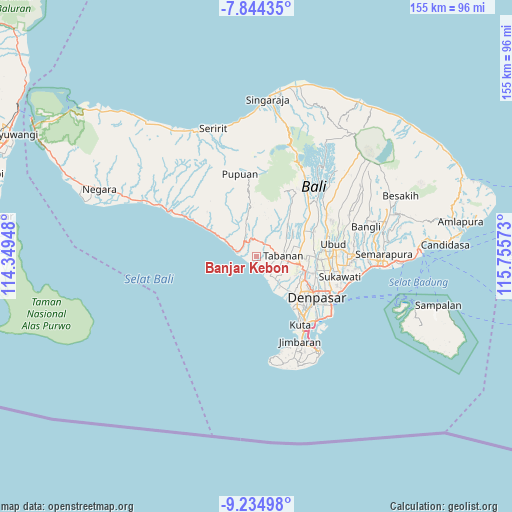
Banjar Kebon GPS coordinates[2]
8° 32' 25.08" South, 115° 3' 9.36" East
| Map corner | latitude | longitude |
|---|---|---|
| Upper-left | -7.84435°, | 114.34948° |
| Center: | -8.5403°, | 115.0526° |
| Lower-right: | -9.23498°, | 115.75573° |
| Map W x H: | 154.6×154.6 km | = 96.1×96.1mi |
| max Lat: | 5.88969° ⇑84.9% North |
| Banjar Kebon: | -8.5403° |
| min Lat: | ⇓15.1% South -10.934° |
| min Long | Banjar Kebon | max Long |
| 95.1345° | 115.0526° | 140.9419° |
| W 71.1%⇐ | ⇒28.9% E |
Elevation
Elevation of Banjar Kebon is 54 m = 177 ft, and this is 175.7 m = 576 ft below average elevation for this country.
| Max E: |
3185 m = 10449 ft | 61.3% |
| Avg. | 229.7 m = 754 ft | |
| Banjar Kebon | 54 m = 177 ft | |
Min E: |
-1 m = -3 ft | 38.7% |
See also: Indonesia elevation on elevation.city.
Geographical zone
Banjar Kebon is located in South Torrid zone (between Equator and Tropic of Capricorn). Distance of Equator is 949.6 km =590.1 mi to North.| Distance of | km | miles | from Banjar Kebon |
|---|---|---|---|
| Equator | 949.6 | 590.1 | to North |
| Tropic Capricorn | 1656.3 | 1029.2 | to South |
| Antarctic Circle | 6451.6 | 4008.8 | to South |
| South Pole | 9057.5 | 5628.1 | to South |


Nearby cities:
15 places around Banjar Kebon: (largest is in red/bold)
• Banjar Baleagung
4.2 km =2.6 mi,  333°
333°
• Banjar Bantasbaleagung
4.4 km =2.7 mi,  24°
24°
• Banjar Baturiti Kaja
3.4 km =2.1 mi,  90°
90°
• Banjar Belumbang Tengah
1.5 km =0.9 mi,  129°
129°
• Banjar Beraban Kangin
2.2 km =1.4 mi,  212°
212°
• Banjar Dauhpangkung
2.5 km =1.6 mi,  102°
102°
• Banjar Dukuh
3.8 km =2.4 mi,  163°
163°
• Banjar Gablogan
4.2 km =2.6 mi,  321°
321°
• Banjar Mambanggede
2.1 km =1.3 mi,  33°
33°
• Banjar Mandung
5 km =3.1 mi,  60°
60°
• Banjar Meliling Kawan
4.7 km =2.9 mi,  43°
43°
• Banjar Pekandelan
3.1 km =1.9 mi,  105°
105°
• Banjar Tegalmengkeb Kaja
2.2 km =1.4 mi,  291°
291°
• Banjar Tibubiyu Kaja
2.1 km =1.3 mi,  188°
188°
• Megati Kelod
4.7 km =2.9 mi,  4°
4°
Sources, notices
• [Note1] Compared only with cities in Indonesia existing in our database
• [Src1] Map data: © OpenStreetMap contributors (CC-BY-SA)
• [Src2] Other city data from geonames.org with taken over terms of usage.
• [Src3] Geographical zone / Annual Mean Temperature by Robert A. Rohde @ Wikipedia
