Jabung geodata
Jabung (East Java) is a seat of a fourth-order administrative division; located in Indonesia in Asia/Jakarta (GMT+7) time zone. In our database, there are 407 cities with bigger population. Compared to other cities in Indonesia, 67.5% of cities are located further ↑North; 51.9% of cities are located further ←West and 61.7% of cities have lower elevation than Jabung. Note1


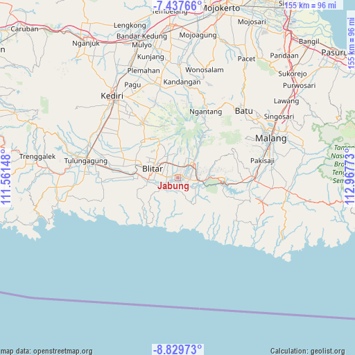
Jabung GPS coordinates[2]
8° 8' 3.48" South, 112° 15' 52.56" East
| Map corner | latitude | longitude |
|---|---|---|
| Upper-left | -7.43766°, | 111.56148° |
| Center: | -8.1343°, | 112.2646° |
| Lower-right: | -8.82973°, | 112.96773° |
| Map W x H: | 154.8×154.8 km | = 96.2×96.2mi |
| max Lat: | 5.88969° ⇑67.5% North |
| Jabung: | -8.1343° |
| min Lat: | ⇓32.5% South -10.934° |
| min Long | Jabung | max Long |
| 95.1345° | 112.2646° | 140.9419° |
| W 51.9%⇐ | ⇒48.1% E |
Elevation
Elevation of Jabung is 182 m = 597 ft, and this is 47.7 m = 156 ft below average elevation for this country.
| Max E: |
3185 m = 10449 ft | 38.3% |
| Avg. | 229.7 m = 754 ft | |
| Jabung | 182 m = 597 ft | |
Min E: |
-1 m = -3 ft | 61.7% |
See also: Indonesia elevation on elevation.city.
Geographical zone
Jabung is located in South Torrid zone (between Equator and Tropic of Capricorn). Distance of Equator is 904.4 km =562 mi to North.| Distance of | km | miles | from Jabung |
|---|---|---|---|
| Equator | 904.4 | 562 | to North |
| Tropic Capricorn | 1701.5 | 1057.3 | to South |
| Antarctic Circle | 6496.7 | 4036.9 | to South |
| South Pole | 9102.6 | 5656.1 | to South |


Nearby cities:
15 places around Jabung: (largest is in red/bold)
• Bendosewu
1.8 km =1.1 mi,  28°
28°
• Duren
2.5 km =1.6 mi,  54°
54°
• Jambewangi
4.6 km =2.9 mi,  85°
85°
• Jeblog Satu
1.8 km =1.1 mi,  352°
352°
• Jegu
3.8 km =2.4 mi,  240°
240°
• Jinglong
5.1 km =3.2 mi,  226°
226°
• Kanigoro
5 km =3.1 mi,  275°
275°
• Kaulon
3.4 km =2.1 mi,  148°
148°
• Mandesan
3.5 km =2.2 mi,  114°
114°
• Mronjo
2 km =1.2 mi,  70°
70°
• Satrejan
4.9 km =3 mi,  258°
258°
• Selopuro
5 km =3.1 mi,  103°
103°
• Sragi
4.4 km =2.7 mi,  57°
57°
• Tumpang
1.7 km =1.1 mi,  318°
318°
• Wonorejo Dua
3.4 km =2.1 mi, 46°
Sources, notices
• [Note1] Compared only with cities in Indonesia existing in our database
• [Src1] Map data: © OpenStreetMap contributors (CC-BY-SA)
• [Src2] Other city data from geonames.org with taken over terms of usage.
• [Src3] Geographical zone / Annual Mean Temperature by Robert A. Rohde @ Wikipedia
