Mujur geodata
Mujur (West Nusa Tenggara) is a seat of a fourth-order administrative division; located in Indonesia in Asia/Makassar (GMT+8) time zone. In our database, there are 407 cities with bigger population. Compared to other cities in Indonesia, 87% of cities are located further ↑North; 77% of cities are located further ←West and 77.2% of cities have lower elevation than Mujur. Note1


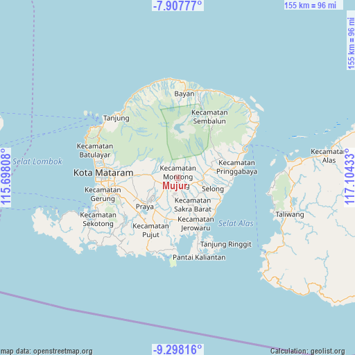
Mujur GPS coordinates[2]
8° 36' 12.96" South, 116° 24' 4.32" East
| Map corner | latitude | longitude |
|---|---|---|
| Upper-left | -7.90777°, | 115.69808° |
| Center: | -8.6036°, | 116.4012° |
| Lower-right: | -9.29816°, | 117.10433° |
| Map W x H: | 154.6×154.6 km | = 96.1×96.1mi |
| max Lat: | 5.88969° ⇑87% North |
| Mujur: | -8.6036° |
| min Lat: | ⇓13% South -10.934° |
| min Long | Mujur | max Long |
| 95.1345° | 116.4012° | 140.9419° |
| W 77%⇐ | ⇒23% E |
Elevation
Elevation of Mujur is 387 m = 1270 ft, and this is 157.3 m = 516 ft above average elevation for this country.
| Max E: |
3185 m = 10449 ft | 22.8% |
| Mujur | 387 m 1270 ft | |
| Avg. | 229.7 m = 754 ft | |
Min E: |
-1 m = -3 ft | 77.2% |
See also: Indonesia elevation on elevation.city.
Geographical zone
Mujur is located in South Torrid zone (between Equator and Tropic of Capricorn). Distance of Equator is 956.6 km =594.4 mi to North.| Distance of | km | miles | from Mujur |
|---|---|---|---|
| Equator | 956.6 | 594.4 | to North |
| Tropic Capricorn | 1649.3 | 1024.8 | to South |
| Antarctic Circle | 6444.5 | 4004.4 | to South |
| South Pole | 9050.4 | 5623.7 | to South |


Nearby cities:
15 places around Mujur: (largest is in red/bold)
• Dalamdesa Selatan
1.6 km =1 mi,  46°
46°
• Dayanpeken
2.5 km =1.6 mi,  59°
59°
• Kampungmasjid
5.4 km =3.4 mi,  83°
83°
• Lendangara Satu
3.2 km =2 mi,  259°
259°
• Lilin Satu
4.4 km =2.7 mi,  246°
246°
• Mejelo Timur
4 km =2.5 mi,  199°
199°
• Montongbaan
4.7 km =2.9 mi,  140°
140°
• Montonggamang
4.7 km =2.9 mi,  223°
223°
• Perian Selatan
4.5 km =2.8 mi,  348°
348°
• Peseng
4 km =2.5 mi,  311°
311°
• Rarang Selatan
4 km =2.5 mi,  191°
191°
• Sukadana Selatan
2.8 km =1.7 mi,  165°
165°
• Terara
4.3 km =2.7 mi, 165°
• Terara Utara
4.2 km =2.6 mi,  161°
161°
• Timba Lauk
5.1 km =3.2 mi,  112°
112°
Sources, notices
• [Note1] Compared only with cities in Indonesia existing in our database
• [Src1] Map data: © OpenStreetMap contributors (CC-BY-SA)
• [Src2] Other city data from geonames.org with taken over terms of usage.
• [Src3] Geographical zone / Annual Mean Temperature by Robert A. Rohde @ Wikipedia
