Aengceleng geodata
Aengceleng (East Java) is a seat of a fourth-order administrative division; located in Indonesia in Asia/Jakarta (GMT+7) time zone. In our database, there are 407 cities with bigger population. Compared to other cities in Indonesia, 59.9% of cities are located further ↑North; 67.8% of cities are located further ←West and 78.9% of cities have higher elevation than Aengceleng. Note1


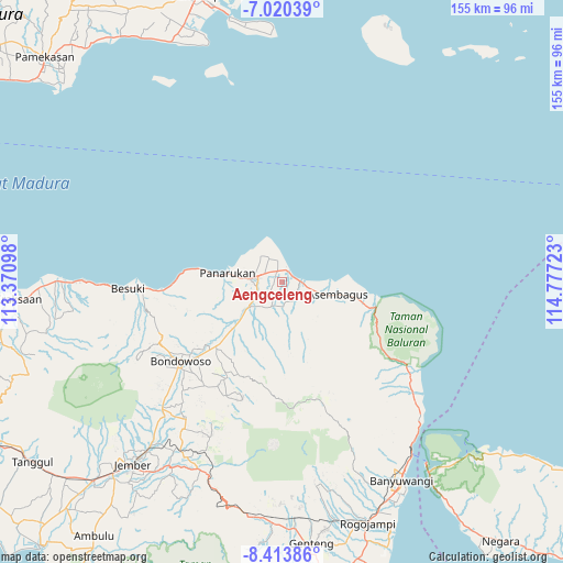
Aengceleng GPS coordinates[2]
7° 43' 3.72" South, 114° 4' 26.76" East
| Map corner | latitude | longitude |
|---|---|---|
| Upper-left | -7.02039°, | 113.37098° |
| Center: | -7.7177°, | 114.0741° |
| Lower-right: | -8.41386°, | 114.77723° |
| Map W x H: | 154.9×154.9 km | = 96.3×96.3mi |
| max Lat: | 5.88969° ⇑59.9% North |
| Aengceleng: | -7.7177° |
| min Lat: | ⇓40.1% South -10.934° |
| min Long | Aengceleng | max Long |
| 95.1345° | 114.0741° | 140.9419° |
| W 67.8%⇐ | ⇒32.2% E |
Elevation
Elevation of Aengceleng is 20 m = 66 ft, and this is 209.7 m = 688 ft below average elevation for this country.
| Max E: |
3185 m = 10449 ft | 78.9% |
| Avg. | 229.7 m = 754 ft | |
| Aengceleng | 20 m = 66 ft | |
Min E: |
-1 m = -3 ft | 21.1% |
See also: Indonesia elevation on elevation.city.
Geographical zone
Aengceleng is located in South Torrid zone (between Equator and Tropic of Capricorn). Distance of Equator is 858.1 km =533.2 mi to North.| Distance of | km | miles | from Aengceleng |
|---|---|---|---|
| Equator | 858.1 | 533.2 | to North |
| Tropic Capricorn | 1747.8 | 1086 | to South |
| Antarctic Circle | 6543 | 4065.6 | to South |
| South Pole | 9148.9 | 5684.9 | to South |


Nearby cities:
15 places around Aengceleng: (largest is in red/bold)
• Bercak
6.6 km =4.1 mi,  192°
192°
• Jatisari Satu
5.9 km =3.7 mi,  149°
149°
• Kapongan
3.3 km =2.1 mi,  335°
335°
• Krajan Battal
4.9 km =3 mi,  227°
227°
• Krajan Curahcotok
1.1 km =0.7 mi,  274°
274°
• Krajan Gebangan
4.8 km =3 mi,  347°
347°
• Krajan Panji Kidul
3.7 km =2.3 mi,  284°
284°
• Krajan Satu Klampokan
4.8 km =3 mi,  210°
210°
• Krajan Satu Panji Lor
4.3 km =2.7 mi,  303°
303°
• Krajan Wonokoyo
1.1 km =0.7 mi,  68°
68°
• Mimbaan Timur
5.3 km =3.3 mi,  292°
292°
• Panji
2.9 km =1.8 mi,  106°
106°
• Selasaan
3.3 km =2.1 mi,  60°
60°
• Sumuranyar
4.3 km =2.7 mi,  197°
197°
• Tokelan Utara
4.9 km =3 mi,  320°
320°
Sources, notices
• [Note1] Compared only with cities in Indonesia existing in our database
• [Src1] Map data: © OpenStreetMap contributors (CC-BY-SA)
• [Src2] Other city data from geonames.org with taken over terms of usage.
• [Src3] Geographical zone / Annual Mean Temperature by Robert A. Rohde @ Wikipedia
