Andekantor geodata
Andekantor (East Nusa Tenggara) is a seat of a fourth-order administrative division; located in Indonesia in Asia/Makassar (GMT+8) time zone. In our database, there are 407 cities with bigger population. Compared to other cities in Indonesia, 93.7% of cities are located further ↑North; 81.5% of cities are located further ←West and 82.9% of cities have lower elevation than Andekantor. Note1


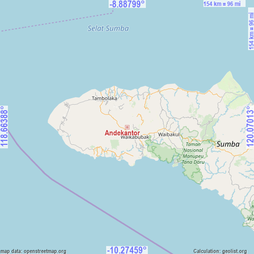
Andekantor GPS coordinates[2]
9° 34' 55.2" South, 119° 22' 1.2" East
| Map corner | latitude | longitude |
|---|---|---|
| Upper-left | -8.88799°, | 118.66388° |
| Center: | -9.582°, | 119.367° |
| Lower-right: | -10.27459°, | 120.07013° |
| Map W x H: | 154.2×154.2 km | = 95.8×95.8mi |
| max Lat: | 5.88969° ⇑93.7% North |
| Andekantor: | -9.582° |
| min Lat: | ⇓6.3% South -10.934° |
| min Long | Andekantor | max Long |
| 95.1345° | 119.367° | 140.9419° |
| W 81.5%⇐ | ⇒18.5% E |
Elevation
Elevation of Andekantor is 478 m = 1568 ft, and this is 248.3 m = 815 ft above average elevation for this country.
| Max E: |
3185 m = 10449 ft | 17.1% |
| Andekantor | 478 m 1568 ft | |
| Avg. | 229.7 m = 754 ft | |
Min E: |
-1 m = -3 ft | 82.9% |
See also: Indonesia elevation on elevation.city.
Geographical zone
Andekantor is located in South Torrid zone (between Equator and Tropic of Capricorn). Distance of Equator is 1065.4 km =662 mi to North.| Distance of | km | miles | from Andekantor |
|---|---|---|---|
| Equator | 1065.4 | 662 | to North |
| Tropic Capricorn | 1540.5 | 957.2 | to South |
| Antarctic Circle | 6335.8 | 3936.9 | to South |
| South Pole | 8941.6 | 5556.1 | to South |


Nearby cities:
15 places around Andekantor: (largest is in red/bold)
• Andelara
7.5 km =4.7 mi,  305°
305°
• Elopada
5.7 km =3.5 mi,  285°
285°
• Komerda
7.3 km =4.5 mi,  139°
139°
• Kotawaikabubak
8.7 km =5.4 mi, 135°
• Maredakalada
5.4 km =3.4 mi,  251°
251°
• Ombarade
7.4 km =4.6 mi, 286°
• Palla
6.3 km =3.9 mi,  348°
348°
• Puukadelu
9 km =5.6 mi,  148°
148°
• Tibutana
8.6 km =5.3 mi,  131°
131°
• Waibakul
7.8 km =4.8 mi, 139°
• Waikabubak
7.7 km =4.8 mi,  161°
161°
• Wailiang
7.4 km =4.6 mi, 143°
• Weegaingo
6.2 km =3.9 mi,  344°
344°
• Weelimbu
3.9 km =2.4 mi,  304°
304°
• Weepanapi
8.7 km =5.4 mi,  84°
84°
Sources, notices
• [Note1] Compared only with cities in Indonesia existing in our database
• [Src1] Map data: © OpenStreetMap contributors (CC-BY-SA)
• [Src2] Other city data from geonames.org with taken over terms of usage.
• [Src3] Geographical zone / Annual Mean Temperature by Robert A. Rohde @ Wikipedia
