Walakeri geodata
Walakeri (East Nusa Tenggara) is a seat of a fourth-order administrative division; located in Indonesia in Asia/Makassar (GMT+8) time zone. In our database, there are 407 cities with bigger population. Compared to other cities in Indonesia, 96.5% of cities are located further ↑North; 83.1% of cities are located further ←West and 65.5% of cities have lower elevation than Walakeri. Note1


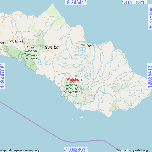
Walakeri GPS coordinates[2]
9° 56' 12.12" South, 120° 9' 3.6" East
| Map corner | latitude | longitude |
|---|---|---|
| Upper-left | -9.24341°, | 119.44788° |
| Center: | -9.9367°, | 120.151° |
| Lower-right: | -10.62853°, | 120.85413° |
| Map W x H: | 154×154 km | = 95.7×95.7mi |
| max Lat: | 5.88969° ⇑96.5% North |
| Walakeri: | -9.9367° |
| min Lat: | ⇓3.5% South -10.934° |
| min Long | Walakeri | max Long |
| 95.1345° | 120.151° | 140.9419° |
| W 83.1%⇐ | ⇒16.9% E |
Elevation
Elevation of Walakeri is 229 m = 751 ft, and this is 0.69999999999999 m = 2 ft below average elevation for this country.
| Max E: |
3185 m = 10449 ft | 34.5% |
| Avg. | 229.7 m = 754 ft | |
| Walakeri | 229 m = 751 ft | |
Min E: |
-1 m = -3 ft | 65.5% |
See also: Indonesia elevation on elevation.city.
Geographical zone
Walakeri is located in South Torrid zone (between Equator and Tropic of Capricorn). Distance of Equator is 1104.9 km =686.6 mi to North.| Distance of | km | miles | from Walakeri |
|---|---|---|---|
| Equator | 1104.9 | 686.6 | to North |
| Tropic Capricorn | 1501.1 | 932.7 | to South |
| Antarctic Circle | 6296.3 | 3912.3 | to South |
| South Pole | 8902.2 | 5531.6 | to South |


Nearby cities:
15 places around Walakeri: (largest is in red/bold)
• Apuhambati
25 km =15.5 mi,  18°
18°
• Bidikotak
12.1 km =7.5 mi, 16°
• Billa
8.1 km =5 mi,  261°
261°
• Kabandang
24 km =14.9 mi,  27°
27°
• Kanjilu
20.4 km =12.7 mi,  329°
329°
• Karita
5.6 km =3.5 mi,  277°
277°
• Laimuda
20.5 km =12.7 mi,  105°
105°
• Laironja
21.1 km =13.1 mi,  138°
138°
• Malahar
8.8 km =5.5 mi, 260°
• Penang
14.6 km =9.1 mi,  45°
45°
• Praingkareha
14.3 km =8.9 mi,  233°
233°
• Tanarara Timur
17.8 km =11.1 mi,  117°
117°
• Tarimbang
21.9 km =13.6 mi, 260°
• Tawui
24.5 km =15.2 mi,  200°
200°
• Wahang Dua
22.2 km =13.8 mi,  217°
217°
Sources, notices
• [Note1] Compared only with cities in Indonesia existing in our database
• [Src1] Map data: © OpenStreetMap contributors (CC-BY-SA)
• [Src2] Other city data from geonames.org with taken over terms of usage.
• [Src3] Geographical zone / Annual Mean Temperature by Robert A. Rohde @ Wikipedia
