Kalumbang geodata
Kalumbang (East Nusa Tenggara) is a seat of a fourth-order administrative division; located in Indonesia in Asia/Makassar (GMT+8) time zone. In our database, there are 407 cities with bigger population. Compared to other cities in Indonesia, 96.2% of cities are located further ↑North; 84.8% of cities are located further ←West and 86.4% of cities have higher elevation than Kalumbang. Note1


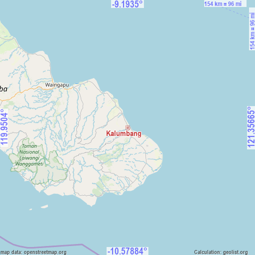
Kalumbang GPS coordinates[2]
9° 53' 12.84" South, 120° 39' 12.672" East
| Map corner | latitude | longitude |
|---|---|---|
| Upper-left | -9.1935°, | 119.9504° |
| Center: | -9.8869°, | 120.65352° |
| Lower-right: | -10.57884°, | 121.35665° |
| Map W x H: | 154×154 km | = 95.7×95.7mi |
| max Lat: | 5.88969° ⇑96.2% North |
| Kalumbang: | -9.8869° |
| min Lat: | ⇓3.8% South -10.934° |
| min Long | Kalumbang | max Long |
| 95.1345° | 120.65352° | 140.9419° |
| W 84.8%⇐ | ⇒15.2% E |
Elevation
Elevation of Kalumbang is 13 m = 43 ft, and this is 216.7 m = 711 ft below average elevation for this country.
| Max E: |
3185 m = 10449 ft | 86.4% |
| Avg. | 229.7 m = 754 ft | |
| Kalumbang | 13 m = 43 ft | |
Min E: |
-1 m = -3 ft | 13.6% |
See also: Indonesia elevation on elevation.city.
Geographical zone
Kalumbang is located in South Torrid zone (between Equator and Tropic of Capricorn). Distance of Equator is 1099.3 km =683.1 mi to North.| Distance of | km | miles | from Kalumbang |
|---|---|---|---|
| Equator | 1099.3 | 683.1 | to North |
| Tropic Capricorn | 1506.6 | 936.2 | to South |
| Antarctic Circle | 6301.9 | 3915.8 | to South |
| South Pole | 8907.7 | 5535 | to South |


Nearby cities:
15 places around Kalumbang: (largest is in red/bold)
• Kandangubuku
1.6 km =1 mi,  355°
355°
• Karawatu
25.6 km =15.9 mi,  323°
323°
• Laau
24.2 km =15 mi,  277°
277°
• Lairoka
18.4 km =11.4 mi,  261°
261°
• Matawaimaringu
12.3 km =7.6 mi,  288°
288°
• Maumaru
21.4 km =13.3 mi,  232°
232°
• Mburukullu
24 km =14.9 mi,  151°
151°
• Palamadu
20.2 km =12.6 mi, 147°
• Patawang
9.1 km =5.7 mi,  338°
338°
• Praimarada
3.5 km =2.2 mi, 262°
• Praiyawang
5.7 km =3.5 mi,  161°
161°
• Rutu
24.2 km =15 mi,  310°
310°
• Tanamiting
27.2 km =16.9 mi, 319°
• Umanggudang
26.2 km =16.3 mi, 225°
• Wanga
16.6 km =10.3 mi,  332°
332°
Sources, notices
• [Note1] Compared only with cities in Indonesia existing in our database
• [Src1] Map data: © OpenStreetMap contributors (CC-BY-SA)
• [Src2] Other city data from geonames.org with taken over terms of usage.
• [Src3] Geographical zone / Annual Mean Temperature by Robert A. Rohde @ Wikipedia
