Kampungsawah Landeuh geodata
Kampungsawah Landeuh (Banten) is a seat of a fourth-order administrative division; located in Indonesia in Asia/Jakarta (GMT+7) time zone. In our database, there are 407 cities with bigger population. Compared to other cities in Indonesia, 87.1% of cities are located further ↓South; 90.9% of cities are located further →East and 80% of cities have lower elevation than Kampungsawah Landeuh. Note1


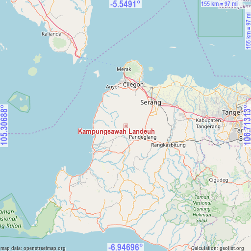
Kampungsawah Landeuh GPS coordinates[2]
6° 14' 54.6" South, 106° 0' 36" East
| Map corner | latitude | longitude |
|---|---|---|
| Upper-left | -5.5491°, | 105.30688° |
| Center: | -6.2485°, | 106.01° |
| Lower-right: | -6.94696°, | 106.71313° |
| Map W x H: | 155.4×155.4 km | = 96.6×96.6mi |
| max Lat: | 5.88969° ⇑12.9% North |
| Kampungsawah Landeuh: | -6.2485° |
| min Lat: | ⇓87.1% South -10.934° |
| min Long | Kampungsawah La | max Long |
| 95.1345° | 106.01° | 140.9419° |
| W 9.1%⇐ | ⇒90.9% E |
Elevation
Elevation of Kampungsawah Landeuh is 432 m = 1417 ft, and this is 202.3 m = 664 ft above average elevation for this country.
| Max E: |
3185 m = 10449 ft | 20% |
| Kampungsawah Landeuh | 432 m 1417 ft | |
| Avg. | 229.7 m = 754 ft | |
Min E: |
-1 m = -3 ft | 80% |
See also: Indonesia elevation on elevation.city.
Geographical zone
Kampungsawah Landeuh is located in South Torrid zone (between Equator and Tropic of Capricorn). Distance of Equator is 694.8 km =431.7 mi to North.| Distance of | km | miles | from Kampungsawah Landeuh |
|---|---|---|---|
| Equator | 694.8 | 431.7 | to North |
| Tropic Capricorn | 1911.2 | 1187.6 | to South |
| Antarctic Circle | 6706.4 | 4167.2 | to South |
| South Pole | 9312.3 | 5786.4 | to South |


Nearby cities:
15 places around Kampungsawah Landeuh: (largest is in red/bold)
• Cikendi
4.5 km =2.8 mi,  19°
19°
• Cilongkrangpusaka
3 km =1.9 mi,  34°
34°
• Ciomas
5.1 km =3.2 mi,  47°
47°
• Cipayung
4.6 km =2.9 mi,  7°
7°
• Citaman
1.8 km =1.1 mi,  37°
37°
• Curuggoong
3.6 km =2.2 mi,  348°
348°
• Kadukoneng
5 km =3.1 mi,  248°
248°
• Kalahang
4 km =2.5 mi,  206°
206°
• Kurungkotok
3.8 km =2.4 mi, 52°
• Lebak
1.3 km =0.8 mi, 9°
• Nagreg
0.9 km =0.6 mi, 211°
• Nengger
5.1 km =3.2 mi,  330°
330°
• Peuteuy
1.6 km =1 mi, 210°
• Sirnagalih
4.7 km =2.9 mi,  197°
197°
• Talagabakti
4.5 km =2.8 mi,  359°
359°
Sources, notices
• [Note1] Compared only with cities in Indonesia existing in our database
• [Src1] Map data: © OpenStreetMap contributors (CC-BY-SA)
• [Src2] Other city data from geonames.org with taken over terms of usage.
• [Src3] Geographical zone / Annual Mean Temperature by Robert A. Rohde @ Wikipedia
