Purabaya geodata
Purabaya (West Java) is a seat of a fourth-order administrative division; located in Indonesia in Asia/Jakarta (GMT+7) time zone. In our database, there are 407 cities with bigger population. Compared to other cities in Indonesia, 51.4% of cities are located further ↑North; 85.4% of cities are located further →East and 62.3% of cities have lower elevation than Purabaya. Note1


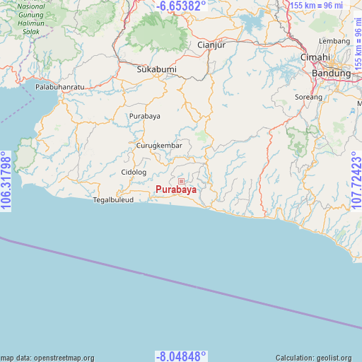
Purabaya GPS coordinates[2]
7° 21' 6.12" South, 107° 1' 15.96" East
| Map corner | latitude | longitude |
|---|---|---|
| Upper-left | -6.65382°, | 106.31798° |
| Center: | -7.3517°, | 107.0211° |
| Lower-right: | -8.04848°, | 107.72423° |
| Map W x H: | 155.1×155.1 km | = 96.4×96.4mi |
| max Lat: | 5.88969° ⇑51.4% North |
| Purabaya: | -7.3517° |
| min Lat: | ⇓48.6% South -10.934° |
| min Long | Purabaya | max Long |
| 95.1345° | 107.0211° | 140.9419° |
| W 14.6%⇐ | ⇒85.4% E |
Elevation
Elevation of Purabaya is 188 m = 617 ft, and this is 41.7 m = 137 ft below average elevation for this country.
| Max E: |
3185 m = 10449 ft | 37.7% |
| Avg. | 229.7 m = 754 ft | |
| Purabaya | 188 m = 617 ft | |
Min E: |
-1 m = -3 ft | 62.3% |
See also: Indonesia elevation on elevation.city.
Geographical zone
Purabaya is located in South Torrid zone (between Equator and Tropic of Capricorn). Distance of Equator is 817.4 km =507.9 mi to North.| Distance of | km | miles | from Purabaya |
|---|---|---|---|
| Equator | 817.4 | 507.9 | to North |
| Tropic Capricorn | 1788.5 | 1111.3 | to South |
| Antarctic Circle | 6583.7 | 4090.9 | to South |
| South Pole | 9189.6 | 5710.2 | to South |


Nearby cities:
15 places around Purabaya: (largest is in red/bold)
• Batukarut
6.7 km =4.2 mi,  353°
353°
• Ciburang
6.3 km =3.9 mi,  335°
335°
• Cihamerang
4.9 km =3 mi,  87°
87°
• Cikendal
5.2 km =3.2 mi,  285°
285°
• Gelarmukti
5.5 km =3.4 mi,  76°
76°
• Jatisari
6.5 km =4 mi,  185°
185°
• Leles
4.8 km =3 mi,  243°
243°
• Nagasari
7.2 km =4.5 mi,  251°
251°
• Pagadungan
7.8 km =4.8 mi,  260°
260°
• Puncakwangi
7.9 km =4.9 mi,  38°
38°
• Selajambe
7.4 km =4.6 mi,  119°
119°
• Sirnasari
3.4 km =2.1 mi,  10°
10°
• Sukamulya
2.5 km =1.6 mi, 251°
• Sukarama
4.9 km =3 mi, 240°
• Sukasirna
1.8 km =1.1 mi,  101°
101°
Sources, notices
• [Note1] Compared only with cities in Indonesia existing in our database
• [Src1] Map data: © OpenStreetMap contributors (CC-BY-SA)
• [Src2] Other city data from geonames.org with taken over terms of usage.
• [Src3] Geographical zone / Annual Mean Temperature by Robert A. Rohde @ Wikipedia
