Cicomre geodata
Cicomre (West Java) is a seat of a fourth-order administrative division; located in Indonesia in Asia/Jakarta (GMT+7) time zone. In our database, there are 407 cities with bigger population. Compared to other cities in Indonesia, 57.9% of cities are located further ↑North; 80.9% of cities are located further →East and 89.8% of cities have lower elevation than Cicomre. Note1


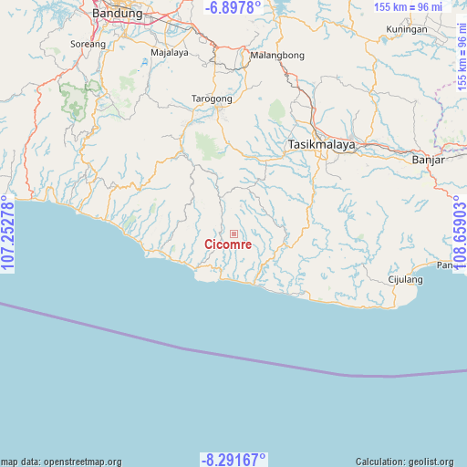
Cicomre GPS coordinates[2]
7° 35' 43.08" South, 107° 57' 21.24" East
| Map corner | latitude | longitude |
|---|---|---|
| Upper-left | -6.8978°, | 107.25278° |
| Center: | -7.5953°, | 107.9559° |
| Lower-right: | -8.29167°, | 108.65903° |
| Map W x H: | 155×155 km | = 96.3×96.3mi |
| max Lat: | 5.88969° ⇑57.9% North |
| Cicomre: | -7.5953° |
| min Lat: | ⇓42.1% South -10.934° |
| min Long | Cicomre | max Long |
| 95.1345° | 107.9559° | 140.9419° |
| W 19.1%⇐ | ⇒80.9% E |
Elevation
Elevation of Cicomre is 634 m = 2080 ft, and this is 404.3 m = 1326 ft above average elevation for this country.
| Max E: |
3185 m = 10449 ft | 10.2% |
| Cicomre | 634 m 2080 ft | |
| Avg. | 229.7 m = 754 ft | |
Min E: |
-1 m = -3 ft | 89.8% |
See also: Indonesia elevation on elevation.city.
Geographical zone
Cicomre is located in South Torrid zone (between Equator and Tropic of Capricorn). Distance of Equator is 844.5 km =524.7 mi to North.| Distance of | km | miles | from Cicomre |
|---|---|---|---|
| Equator | 844.5 | 524.7 | to North |
| Tropic Capricorn | 1761.4 | 1094.5 | to South |
| Antarctic Circle | 6556.7 | 4074.1 | to South |
| South Pole | 9162.5 | 5693.3 | to South |


Nearby cities:
15 places around Cicomre: (largest is in red/bold)
• Awilega
7 km =4.3 mi,  26°
26°
• Ciawi
9.6 km =6 mi,  13°
13°
• Cikawung
6.7 km =4.2 mi,  92°
92°
• Cipicung
9.4 km =5.8 mi,  62°
62°
• Cirangkong
4.3 km =2.7 mi,  223°
223°
• Datarnangka
2.7 km =1.7 mi,  3°
3°
• Kertanegla
9.2 km =5.7 mi, 1°
• Maroko
8.3 km =5.2 mi,  237°
237°
• Nagrog
7.8 km =4.8 mi,  156°
156°
• Pangrumasan
7.2 km =4.5 mi,  296°
296°
• Parabon
7.7 km =4.8 mi,  329°
329°
• Pasirirnem
4.9 km =3 mi,  314°
314°
• Saribakti
7.4 km =4.6 mi,  337°
337°
• Simpang
7.4 km =4.6 mi,  227°
227°
• Toblong
5.6 km =3.5 mi, 313°
Sources, notices
• [Note1] Compared only with cities in Indonesia existing in our database
• [Src1] Map data: © OpenStreetMap contributors (CC-BY-SA)
• [Src2] Other city data from geonames.org with taken over terms of usage.
• [Src3] Geographical zone / Annual Mean Temperature by Robert A. Rohde @ Wikipedia
