Astana Hilir geodata
Astana Hilir (West Java) is a seat of a fourth-order administrative division; located in Indonesia in Asia/Jakarta (GMT+7) time zone. In our database, there are 407 cities with bigger population. Compared to other cities in Indonesia, 54.6% of cities are located further ↓South; 82.3% of cities are located further →East and 93.4% of cities have lower elevation than Astana Hilir. Note1


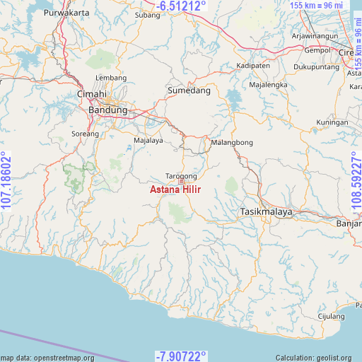
Astana Hilir GPS coordinates[2]
7° 12' 36.756" South, 107° 53' 20.904" East
| Map corner | latitude | longitude |
|---|---|---|
| Upper-left | -6.51212°, | 107.18602° |
| Center: | -7.21021°, | 107.88914° |
| Lower-right: | -7.90722°, | 108.59227° |
| Map W x H: | 155.1×155.1 km | = 96.4×96.4mi |
| max Lat: | 5.88969° ⇑45.4% North |
| Astana Hilir: | -7.21021° |
| min Lat: | ⇓54.6% South -10.934° |
| min Long | Astana Hilir | max Long |
| 95.1345° | 107.88914° | 140.9419° |
| W 17.7%⇐ | ⇒82.3% E |
Elevation
Elevation of Astana Hilir is 746 m = 2448 ft, and this is 516.3 m = 1694 ft above average elevation for this country.
| Max E: |
3185 m = 10449 ft | 6.6% |
| Astana Hilir | 746 m 2448 ft | |
| Avg. | 229.7 m = 754 ft | |
Min E: |
-1 m = -3 ft | 93.4% |
See also: Indonesia elevation on elevation.city.
Geographical zone
Astana Hilir is located in South Torrid zone (between Equator and Tropic of Capricorn). Distance of Equator is 801.7 km =498.2 mi to North.| Distance of | km | miles | from Astana Hilir |
|---|---|---|---|
| Equator | 801.7 | 498.2 | to North |
| Tropic Capricorn | 1804.2 | 1121.1 | to South |
| Antarctic Circle | 6599.5 | 4100.7 | to South |
| South Pole | 9205.4 | 5720 | to South |


Nearby cities:
15 places around Astana Hilir: (largest is in red/bold)
• Besarmanah
1.7 km =1.1 mi,  169°
169°
• Cireundang
1.6 km =1 mi,  312°
312°
• Garut
0.9 km =0.6 mi,  350°
350°
• Haurpanggung
1.8 km =1.1 mi,  73°
73°
• Jangkurang Kidul
2.2 km =1.4 mi,  81°
81°
• Jayaraga Kaler
1.4 km =0.9 mi,  62°
62°
• Kalidung
2.1 km =1.3 mi,  3°
3°
• Mawar
1.8 km =1.1 mi,  97°
97°
• Nagara Tengah
2 km =1.2 mi,  341°
341°
• Pakuwon
1.7 km =1.1 mi,  110°
110°
• Panawuan
0.7 km =0.4 mi,  227°
227°
• Panunggangan
1.9 km =1.2 mi,  185°
185°
• Pataruman
1.3 km =0.8 mi,  20°
20°
• Rengganis
1.1 km =0.7 mi, 104°
• Tarogong
2.2 km =1.4 mi,  355°
355°
Sources, notices
• [Note1] Compared only with cities in Indonesia existing in our database
• [Src1] Map data: © OpenStreetMap contributors (CC-BY-SA)
• [Src2] Other city data from geonames.org with taken over terms of usage.
• [Src3] Geographical zone / Annual Mean Temperature by Robert A. Rohde @ Wikipedia
