Cilolohan geodata
Cilolohan (West Java) is a seat of a fourth-order administrative division; located in Indonesia in Asia/Jakarta (GMT+7) time zone. In our database, there are 407 cities with bigger population. Compared to other cities in Indonesia, 56.1% of cities are located further ↓South; 81.7% of cities are located further →East and 91.6% of cities have lower elevation than Cilolohan. Note1


Cilolohan GPS coordinates[2]
7° 10' 51.6" South, 107° 54' 45.72" East
| Map corner | latitude | longitude |
|---|---|---|
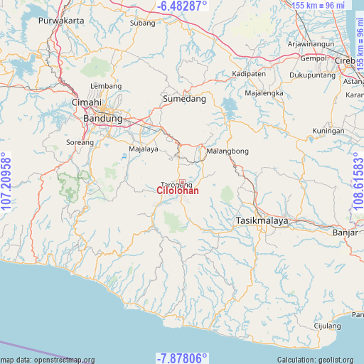
| Upper-left | -6.48287°, | 107.20958° |
| Center: | -7.181°, | 107.9127° |
| Lower-right: | -7.87806°, | 108.61583° |
| Map W x H: | 155.1×155.1 km | = 96.4×96.4mi |
| max Lat: | 5.88969° ⇑43.9% North |
| Cilolohan: | -7.181° |
| min Lat: | ⇓56.1% South -10.934° |
| min Long | Cilolohan | max Long |
| 95.1345° | 107.9127° | 140.9419° |
| W 18.3%⇐ | ⇒81.7% E |
Elevation
Elevation of Cilolohan is 698 m = 2290 ft, and this is 468.3 m = 1536 ft above average elevation for this country.
| Max E: |
3185 m = 10449 ft | 8.4% |
| Cilolohan | 698 m 2290 ft | |
| Avg. | 229.7 m = 754 ft | |
Min E: |
-1 m = -3 ft | 91.6% |
See also: Indonesia elevation on elevation.city.
Geographical zone
Cilolohan is located in South Torrid zone (between Equator and Tropic of Capricorn). Distance of Equator is 798.5 km =496.2 mi to North.| Distance of | km | miles | from Cilolohan |
|---|---|---|---|
| Equator | 798.5 | 496.2 | to North |
| Tropic Capricorn | 1807.5 | 1123.1 | to South |
| Antarctic Circle | 6602.7 | 4102.7 | to South |
| South Pole | 9208.6 | 5722 | to South |


Nearby cities:
15 places around Cilolohan: (largest is in red/bold)
• Andir
3.2 km =2 mi,  336°
336°
• Babakan
3 km =1.9 mi,  355°
355°
• Haurpanggung
2.9 km =1.8 mi,  197°
197°
• Jangkurang Kidul
2.9 km =1.8 mi,  188°
188°
• Jayaraga Kaler
2.9 km =1.8 mi,  207°
207°
• Kalidung
2.7 km =1.7 mi,  245°
245°
• Karangmulya
3.4 km =2.1 mi,  148°
148°
• Lengkongjaya
2.8 km =1.7 mi,  140°
140°
• Ngompot
1 km =0.6 mi,  27°
27°
• Pangkalan
3.1 km =1.9 mi,  277°
277°
• Pataruman
3 km =1.9 mi,  226°
226°
• Perum
2.1 km =1.3 mi,  306°
306°
• Tarogong
3 km =1.9 mi, 249°
• Tegaljati
2.4 km =1.5 mi,  129°
129°
• Warungtanjung
2.5 km =1.6 mi,  303°
303°
Sources, notices
• [Note1] Compared only with cities in Indonesia existing in our database
• [Src1] Map data: © OpenStreetMap contributors (CC-BY-SA)
• [Src2] Other city data from geonames.org with taken over terms of usage.
• [Src3] Geographical zone / Annual Mean Temperature by Robert A. Rohde @ Wikipedia
