Gintung geodata
Gintung (West Java) is a seat of a fourth-order administrative division; located in Indonesia in Asia/Jakarta (GMT+7) time zone. In our database, there are 407 cities with bigger population. Compared to other cities in Indonesia, 59.1% of cities are located further ↑North; 79.4% of cities are located further →East and 66.3% of cities have lower elevation than Gintung. Note1


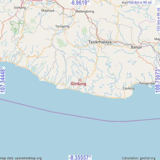
Gintung GPS coordinates[2]
7° 39' 33.48" South, 108° 2' 51.36" East
| Map corner | latitude | longitude |
|---|---|---|
| Upper-left | -6.9619°, | 107.34448° |
| Center: | -7.6593°, | 108.0476° |
| Lower-right: | -8.35557°, | 108.75073° |
| Map W x H: | 155×155 km | = 96.3×96.3mi |
| max Lat: | 5.88969° ⇑59.1% North |
| Gintung: | -7.6593° |
| min Lat: | ⇓40.9% South -10.934° |
| min Long | Gintung | max Long |
| 95.1345° | 108.0476° | 140.9419° |
| W 20.6%⇐ | ⇒79.4% E |
Elevation
Elevation of Gintung is 243 m = 797 ft, and this is 13.3 m = 44 ft above average elevation for this country.
| Max E: |
3185 m = 10449 ft | 33.7% |
| Gintung | 243 m 797 ft | |
| Avg. | 229.7 m = 754 ft | |
Min E: |
-1 m = -3 ft | 66.3% |
See also: Indonesia elevation on elevation.city.
Geographical zone
Gintung is located in South Torrid zone (between Equator and Tropic of Capricorn). Distance of Equator is 851.6 km =529.2 mi to North.| Distance of | km | miles | from Gintung |
|---|---|---|---|
| Equator | 851.6 | 529.2 | to North |
| Tropic Capricorn | 1754.3 | 1090.1 | to South |
| Antarctic Circle | 6549.5 | 4069.7 | to South |
| South Pole | 9155.4 | 5688.9 | to South |


Nearby cities:
15 places around Gintung: (largest is in red/bold)
• Babakankadu
2.3 km =1.4 mi,  265°
265°
• Burujul Tengah
4.4 km =2.7 mi,  39°
39°
• Cibatear
2.9 km =1.8 mi,  325°
325°
• Ciceuri
2.6 km =1.6 mi,  175°
175°
• Cikadu
7.1 km =4.4 mi,  9°
9°
• Cikaret
8.1 km =5 mi,  79°
79°
• Cikatulampa
3.7 km =2.3 mi, 181°
• Cikawung
7.6 km =4.7 mi, 333°
• Cilangla
8.4 km =5.2 mi,  102°
102°
• Gawul
3.4 km =2.1 mi,  91°
91°
• Leuwipicung
7.1 km =4.4 mi,  153°
153°
• Menol
4.8 km =3 mi,  67°
67°
• Nagrog
7 km =4.3 mi, 269°
• Pasirtujuhpuluh
7 km =4.3 mi,  59°
59°
• Simpang
7.6 km =4.7 mi, 58°
Sources, notices
• [Note1] Compared only with cities in Indonesia existing in our database
• [Src1] Map data: © OpenStreetMap contributors (CC-BY-SA)
• [Src2] Other city data from geonames.org with taken over terms of usage.
• [Src3] Geographical zone / Annual Mean Temperature by Robert A. Rohde @ Wikipedia
