Surabaya geodata
Surabaya (West Java) is a seat of a fourth-order administrative division; located in Indonesia in Asia/Jakarta (GMT+7) time zone. In our database, there are 407 cities with bigger population. Compared to other cities in Indonesia, 64.3% of cities are located further ↓South; 79.7% of cities are located further →East and 85% of cities have lower elevation than Surabaya. Note1


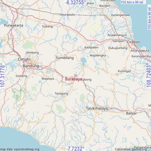
Surabaya GPS coordinates[2]
7° 1' 33.24" South, 108° 1' 15.24" East
| Map corner | latitude | longitude |
|---|---|---|
| Upper-left | -6.32755°, | 107.31778° |
| Center: | -7.0259°, | 108.0209° |
| Lower-right: | -7.7232°, | 108.72403° |
| Map W x H: | 155.2×155.2 km | = 96.4×96.4mi |
| max Lat: | 5.88969° ⇑35.7% North |
| Surabaya: | -7.0259° |
| min Lat: | ⇓64.3% South -10.934° |
| min Long | Surabaya | max Long |
| 95.1345° | 108.0209° | 140.9419° |
| W 20.3%⇐ | ⇒79.7% E |
Elevation
Elevation of Surabaya is 518 m = 1699 ft, and this is 288.3 m = 946 ft above average elevation for this country.
| Max E: |
3185 m = 10449 ft | 15% |
| Surabaya | 518 m 1699 ft | |
| Avg. | 229.7 m = 754 ft | |
Min E: |
-1 m = -3 ft | 85% |
See also: Indonesia elevation on elevation.city.
Geographical zone
Surabaya is located in South Torrid zone (between Equator and Tropic of Capricorn). Distance of Equator is 781.2 km =485.4 mi to North.| Distance of | km | miles | from Surabaya |
|---|---|---|---|
| Equator | 781.2 | 485.4 | to North |
| Tropic Capricorn | 1824.7 | 1133.8 | to South |
| Antarctic Circle | 6620 | 4113.5 | to South |
| South Pole | 9225.9 | 5732.7 | to South |


Nearby cities:
15 places around Surabaya: (largest is in red/bold)
• Babakancikaso
2 km =1.2 mi,  293°
293°
• Bakom
2.6 km =1.6 mi,  255°
255°
• Bandrek
3.5 km =2.2 mi,  200°
200°
• Cigadog
3.6 km =2.2 mi,  132°
132°
• Cigaluh
3.9 km =2.4 mi,  219°
219°
• Cihayam
2 km =1.2 mi,  355°
355°
• Ciloa
0.8 km =0.5 mi,  46°
46°
• Gempol
2.9 km =1.8 mi,  245°
245°
• Kubang
3 km =1.9 mi,  181°
181°
• Kudang
4.1 km =2.5 mi, 258°
• Kurnia
3.4 km =2.1 mi,  149°
149°
• Pulosari
1.9 km =1.2 mi,  348°
348°
• Putrajawa
2.5 km =1.6 mi,  334°
334°
• Rancapanjang
1.7 km =1.1 mi,  266°
266°
• Sindangkopo
2.7 km =1.7 mi,  17°
17°
Sources, notices
• [Note1] Compared only with cities in Indonesia existing in our database
• [Src1] Map data: © OpenStreetMap contributors (CC-BY-SA)
• [Src2] Other city data from geonames.org with taken over terms of usage.
• [Src3] Geographical zone / Annual Mean Temperature by Robert A. Rohde @ Wikipedia
