Tegalgede geodata
Tegalgede (West Java) is a seat of a fourth-order administrative division; located in Indonesia in Asia/Jakarta (GMT+7) time zone. In our database, there are 407 cities with bigger population. Compared to other cities in Indonesia, 56% of cities are located further ↓South; 80% of cities are located further →East and 95% of cities have lower elevation than Tegalgede. Note1


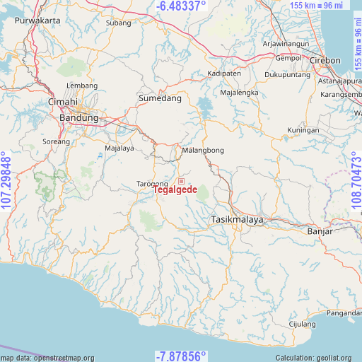
Tegalgede GPS coordinates[2]
7° 10' 53.4" South, 108° 0' 5.76" East
| Map corner | latitude | longitude |
|---|---|---|
| Upper-left | -6.48337°, | 107.29848° |
| Center: | -7.1815°, | 108.0016° |
| Lower-right: | -7.87856°, | 108.70473° |
| Map W x H: | 155.1×155.1 km | = 96.4×96.4mi |
| max Lat: | 5.88969° ⇑44% North |
| Tegalgede: | -7.1815° |
| min Lat: | ⇓56% South -10.934° |
| min Long | Tegalgede | max Long |
| 95.1345° | 108.0016° | 140.9419° |
| W 20%⇐ | ⇒80% E |
Elevation
Elevation of Tegalgede is 818 m = 2684 ft, and this is 588.3 m = 1930 ft above average elevation for this country.
| Max E: |
3185 m = 10449 ft | 5% |
| Tegalgede | 818 m 2684 ft | |
| Avg. | 229.7 m = 754 ft | |
Min E: |
-1 m = -3 ft | 95% |
See also: Indonesia elevation on elevation.city.
Geographical zone
Tegalgede is located in South Torrid zone (between Equator and Tropic of Capricorn). Distance of Equator is 798.5 km =496.2 mi to North.| Distance of | km | miles | from Tegalgede |
|---|---|---|---|
| Equator | 798.5 | 496.2 | to North |
| Tropic Capricorn | 1807.4 | 1123.1 | to South |
| Antarctic Circle | 6602.7 | 4102.7 | to South |
| South Pole | 9208.6 | 5722 | to South |


Nearby cities:
15 places around Tegalgede: (largest is in red/bold)
• Babakanloa
2.4 km =1.5 mi,  346°
346°
• Bebedahan
2.4 km =1.5 mi,  278°
278°
• Cibeureum
2.6 km =1.6 mi,  339°
339°
• Cihuni Kaler
2 km =1.2 mi,  326°
326°
• Cipeucang
2.5 km =1.6 mi,  14°
14°
• Citangtu Kaler
2.1 km =1.3 mi,  318°
318°
• Panyingkiran
2.2 km =1.4 mi,  118°
118°
• Pasanggrahan
2.2 km =1.4 mi,  20°
20°
• Pataruman
2 km =1.2 mi,  214°
214°
• Samanggen
2.5 km =1.6 mi,  307°
307°
• Sukaraja
2 km =1.2 mi,  355°
355°
• Sukarasa
2.3 km =1.4 mi, 356°
• Tajurdesa
2.6 km =1.6 mi,  165°
165°
• Tegalpanjang
2.3 km =1.4 mi,  236°
236°
• Wanaraja
2.4 km =1.5 mi,  287°
287°
Sources, notices
• [Note1] Compared only with cities in Indonesia existing in our database
• [Src1] Map data: © OpenStreetMap contributors (CC-BY-SA)
• [Src2] Other city data from geonames.org with taken over terms of usage.
• [Src3] Geographical zone / Annual Mean Temperature by Robert A. Rohde @ Wikipedia
