Sukahurip geodata
Sukahurip (West Java) is a seat of a fourth-order administrative division; located in Indonesia in Asia/Jakarta (GMT+7) time zone. In our database, there are 407 cities with bigger population. Compared to other cities in Indonesia, 54.5% of cities are located further ↑North; 77% of cities are located further →East and 67.5% of cities have lower elevation than Sukahurip. Note1


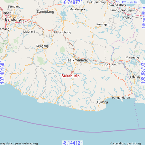
Sukahurip GPS coordinates[2]
7° 26' 51" South, 108° 11' 5.28" East
| Map corner | latitude | longitude |
|---|---|---|
| Upper-left | -6.74977°, | 107.48168° |
| Center: | -7.4475°, | 108.1848° |
| Lower-right: | -8.14412°, | 108.88793° |
| Map W x H: | 155×155 km | = 96.3×96.3mi |
| max Lat: | 5.88969° ⇑54.5% North |
| Sukahurip: | -7.4475° |
| min Lat: | ⇓45.5% South -10.934° |
| min Long | Sukahurip | max Long |
| 95.1345° | 108.1848° | 140.9419° |
| W 23%⇐ | ⇒77% E |
Elevation
Elevation of Sukahurip is 258 m = 846 ft, and this is 28.3 m = 93 ft above average elevation for this country.
| Max E: |
3185 m = 10449 ft | 32.5% |
| Sukahurip | 258 m 846 ft | |
| Avg. | 229.7 m = 754 ft | |
Min E: |
-1 m = -3 ft | 67.5% |
See also: Indonesia elevation on elevation.city.
Geographical zone
Sukahurip is located in South Torrid zone (between Equator and Tropic of Capricorn). Distance of Equator is 828.1 km =514.6 mi to North.| Distance of | km | miles | from Sukahurip |
|---|---|---|---|
| Equator | 828.1 | 514.6 | to North |
| Tropic Capricorn | 1777.8 | 1104.7 | to South |
| Antarctic Circle | 6573.1 | 4084.3 | to South |
| South Pole | 9179 | 5703.6 | to South |


Nearby cities:
15 places around Sukahurip: (largest is in red/bold)
• Cijoho
3.4 km =2.1 mi,  283°
283°
• Cimawate
3 km =1.9 mi,  354°
354°
• Citamiang
4.6 km =2.9 mi,  1°
1°
• Cukangawi
4.5 km =2.8 mi,  344°
344°
• Garunggang
4.7 km =2.9 mi,  115°
115°
• Kampungbaru
5.6 km =3.5 mi,  211°
211°
• Kiaranonggeng
5.3 km =3.3 mi,  297°
297°
• Papayan
2.7 km =1.7 mi,  135°
135°
• Parakantiga
1.1 km =0.7 mi, 142°
• Pasir
3 km =1.9 mi,  182°
182°
• Sukamaju
1.9 km =1.2 mi,  29°
29°
• Sukaraja
1.2 km =0.7 mi,  114°
114°
• Tamansari
2.9 km =1.8 mi,  18°
18°
• Tambakbaya
5 km =3.1 mi, 352°
• Unden
2.9 km =1.8 mi, 105°
Sources, notices
• [Note1] Compared only with cities in Indonesia existing in our database
• [Src1] Map data: © OpenStreetMap contributors (CC-BY-SA)
• [Src2] Other city data from geonames.org with taken over terms of usage.
• [Src3] Geographical zone / Annual Mean Temperature by Robert A. Rohde @ Wikipedia
