Pengkolan geodata
Pengkolan (West Java) is a seat of a fourth-order administrative division; located in Indonesia in Asia/Jakarta (GMT+7) time zone. In our database, there are 407 cities with bigger population. Compared to other cities in Indonesia, 51% of cities are located further ↓South; 75.6% of cities are located further →East and 73.6% of cities have lower elevation than Pengkolan. Note1


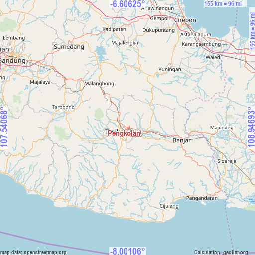
Pengkolan GPS coordinates[2]
7° 18' 15.12" South, 108° 14' 37.68" East
| Map corner | latitude | longitude |
|---|---|---|
| Upper-left | -6.60625°, | 107.54068° |
| Center: | -7.3042°, | 108.2438° |
| Lower-right: | -8.00106°, | 108.94693° |
| Map W x H: | 155.1×155.1 km | = 96.4×96.4mi |
| max Lat: | 5.88969° ⇑49% North |
| Pengkolan: | -7.3042° |
| min Lat: | ⇓51% South -10.934° |
| min Long | Pengkolan | max Long |
| 95.1345° | 108.2438° | 140.9419° |
| W 24.4%⇐ | ⇒75.6% E |
Elevation
Elevation of Pengkolan is 341 m = 1119 ft, and this is 111.3 m = 365 ft above average elevation for this country.
| Max E: |
3185 m = 10449 ft | 26.4% |
| Pengkolan | 341 m 1119 ft | |
| Avg. | 229.7 m = 754 ft | |
Min E: |
-1 m = -3 ft | 73.6% |
See also: Indonesia elevation on elevation.city.
Geographical zone
Pengkolan is located in South Torrid zone (between Equator and Tropic of Capricorn). Distance of Equator is 812.2 km =504.7 mi to North.| Distance of | km | miles | from Pengkolan |
|---|---|---|---|
| Equator | 812.2 | 504.7 | to North |
| Tropic Capricorn | 1793.8 | 1114.6 | to South |
| Antarctic Circle | 6589 | 4094.2 | to South |
| South Pole | 9194.9 | 5713.4 | to South |


Nearby cities:
15 places around Pengkolan: (largest is in red/bold)
• Bojongnangka
3.1 km =1.9 mi,  167°
167°
• Cibogor
1.9 km =1.2 mi,  234°
234°
• Cihideung Satu
2.5 km =1.6 mi,  330°
330°
• Cikoneng
3.1 km =1.9 mi,  105°
105°
• Cimamut
1.7 km =1.1 mi,  119°
119°
• Desa Kaler Gunungcupu
1.9 km =1.2 mi,  304°
304°
• Desa Margaluyu
1.4 km =0.9 mi, 107°
• Gunungpeundeuy
2.3 km =1.4 mi,  158°
158°
• Mancogeh
3 km =1.9 mi,  260°
260°
• Nagarasari
2.5 km =1.6 mi,  279°
279°
• Panyingkiran
2.5 km =1.6 mi,  68°
68°
• Pasar Sabtu
2.6 km =1.6 mi,  104°
104°
• Sukasari
2.7 km =1.7 mi,  208°
208°
• Tugu
1 km =0.6 mi,  21°
21°
• Walahir
3 km =1.9 mi, 24°
Sources, notices
• [Note1] Compared only with cities in Indonesia existing in our database
• [Src1] Map data: © OpenStreetMap contributors (CC-BY-SA)
• [Src2] Other city data from geonames.org with taken over terms of usage.
• [Src3] Geographical zone / Annual Mean Temperature by Robert A. Rohde @ Wikipedia
