Rajamandala geodata
Rajamandala (West Java) is a seat of a fourth-order administrative division; located in Indonesia in Asia/Jakarta (GMT+7) time zone. In our database, there are 407 cities with bigger population. Compared to other cities in Indonesia, 55.9% of cities are located further ↓South; 77.1% of cities are located further →East and 83.2% of cities have lower elevation than Rajamandala. Note1


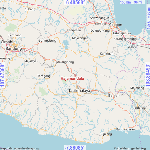
Rajamandala GPS coordinates[2]
7° 11' 1.68" South, 108° 10' 54.48" East
| Map corner | latitude | longitude |
|---|---|---|
| Upper-left | -6.48568°, | 107.47868° |
| Center: | -7.1838°, | 108.1818° |
| Lower-right: | -7.88085°, | 108.88493° |
| Map W x H: | 155.1×155.1 km | = 96.4×96.4mi |
| max Lat: | 5.88969° ⇑44.1% North |
| Rajamandala: | -7.1838° |
| min Lat: | ⇓55.9% South -10.934° |
| min Long | Rajamandala | max Long |
| 95.1345° | 108.1818° | 140.9419° |
| W 22.9%⇐ | ⇒77.1% E |
Elevation
Elevation of Rajamandala is 483 m = 1585 ft, and this is 253.3 m = 831 ft above average elevation for this country.
| Max E: |
3185 m = 10449 ft | 16.8% |
| Rajamandala | 483 m 1585 ft | |
| Avg. | 229.7 m = 754 ft | |
Min E: |
-1 m = -3 ft | 83.2% |
See also: Indonesia elevation on elevation.city.
Geographical zone
Rajamandala is located in South Torrid zone (between Equator and Tropic of Capricorn). Distance of Equator is 798.8 km =496.4 mi to North.| Distance of | km | miles | from Rajamandala |
|---|---|---|---|
| Equator | 798.8 | 496.4 | to North |
| Tropic Capricorn | 1807.2 | 1122.9 | to South |
| Antarctic Circle | 6602.4 | 4102.5 | to South |
| South Pole | 9208.3 | 5721.8 | to South |


Nearby cities:
15 places around Rajamandala: (largest is in red/bold)
• Cihonje
1.1 km =0.7 mi,  145°
145°
• Ciinjuk
2.6 km =1.6 mi,  167°
167°
• Ciomas
1.5 km =0.9 mi,  293°
293°
• Cipanjang
3 km =1.9 mi,  330°
330°
• Condong
3.1 km =1.9 mi,  239°
239°
• Jamanis
0.7 km =0.4 mi,  162°
162°
• Kampungdesa Pamokolan
2.5 km =1.6 mi,  126°
126°
• Nyalindung
1 km =0.6 mi,  216°
216°
• Padamulya
3.1 km =1.9 mi, 133°
• Pasireurih
2 km =1.2 mi,  63°
63°
• Sindangharja
2.5 km =1.6 mi,  7°
7°
• Singabarong
1.7 km =1.1 mi,  192°
192°
• Sukamenak
1.6 km =1 mi,  357°
357°
• Sukaraja
3.1 km =1.9 mi, 190°
• Sukasenang
2.2 km =1.4 mi,  313°
313°
Sources, notices
• [Note1] Compared only with cities in Indonesia existing in our database
• [Src1] Map data: © OpenStreetMap contributors (CC-BY-SA)
• [Src2] Other city data from geonames.org with taken over terms of usage.
• [Src3] Geographical zone / Annual Mean Temperature by Robert A. Rohde @ Wikipedia
