Simpang geodata
Simpang (West Java) is a seat of a fourth-order administrative division; located in Indonesia in Asia/Jakarta (GMT+7) time zone. In our database, there are 407 cities with bigger population. Compared to other cities in Indonesia, 53.8% of cities are located further ↑North; 84.7% of cities are located further →East and 83% of cities have higher elevation than Simpang. Note1


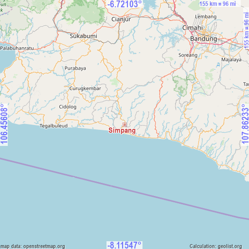
Simpang GPS coordinates[2]
7° 25' 7.68" South, 107° 9' 33.12" East
| Map corner | latitude | longitude |
|---|---|---|
| Upper-left | -6.72103°, | 106.45608° |
| Center: | -7.4188°, | 107.1592° |
| Lower-right: | -8.11547°, | 107.86233° |
| Map W x H: | 155×155.1 km | = 96.3×96.4mi |
| max Lat: | 5.88969° ⇑53.8% North |
| Simpang: | -7.4188° |
| min Lat: | ⇓46.2% South -10.934° |
| min Long | Simpang | max Long |
| 95.1345° | 107.1592° | 140.9419° |
| W 15.3%⇐ | ⇒84.7% E |
Elevation
Elevation of Simpang is 16 m = 52 ft, and this is 213.7 m = 701 ft below average elevation for this country.
| Max E: |
3185 m = 10449 ft | 83% |
| Avg. | 229.7 m = 754 ft | |
| Simpang | 16 m = 52 ft | |
Min E: |
-1 m = -3 ft | 17% |
See also: Indonesia elevation on elevation.city.
Geographical zone
Simpang is located in South Torrid zone (between Equator and Tropic of Capricorn). Distance of Equator is 824.9 km =512.6 mi to North.| Distance of | km | miles | from Simpang |
|---|---|---|---|
| Equator | 824.9 | 512.6 | to North |
| Tropic Capricorn | 1781 | 1106.7 | to South |
| Antarctic Circle | 6576.3 | 4086.3 | to South |
| South Pole | 9182.2 | 5705.6 | to South |


Nearby cities:
15 places around Simpang: (largest is in red/bold)
• Batulawang
5.8 km =3.6 mi,  350°
350°
• Cigarogol
8.2 km =5.1 mi,  139°
139°
• Cimalati
7 km =4.3 mi,  65°
65°
• Cireundeu
10.6 km =6.6 mi,  358°
358°
• Kendalngupuk
10.9 km =6.8 mi,  104°
104°
• Mekarsari
7.4 km =4.6 mi,  246°
246°
• Muaracikadu
0.6 km =0.4 mi,  237°
237°
• Pamadangan
9.6 km =6 mi,  9°
9°
• Panyindangan
7.6 km =4.7 mi,  289°
289°
• Puncak
4.9 km =3 mi,  227°
227°
• Selajambe
9.5 km =5.9 mi, 293°
• Simpang
8.5 km =5.3 mi,  48°
48°
• Sindangbarang
4.5 km =2.8 mi,  215°
215°
• Solokpandan
10.3 km =6.4 mi,  26°
26°
• Sukarame
10.1 km =6.3 mi,  266°
266°
Sources, notices
• [Note1] Compared only with cities in Indonesia existing in our database
• [Src1] Map data: © OpenStreetMap contributors (CC-BY-SA)
• [Src2] Other city data from geonames.org with taken over terms of usage.
• [Src3] Geographical zone / Annual Mean Temperature by Robert A. Rohde @ Wikipedia
