Sukadana geodata
Sukadana (West Java) is a seat of a third-order administrative division; located in Indonesia in Asia/Jakarta (GMT+7) time zone. In our database, there are 407 cities with bigger population. Compared to other cities in Indonesia, 52.5% of cities are located further ↓South; 72.3% of cities are located further →East and 63.6% of cities have lower elevation than Sukadana. Note1


Sukadana GPS coordinates[2]
7° 15' 55.8" South, 108° 26' 25.08" East
| Map corner | latitude | longitude |
|---|---|---|
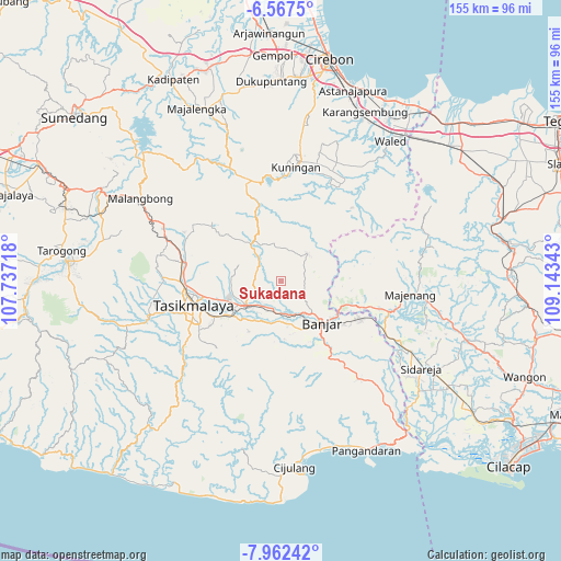
| Upper-left | -6.5675°, | 107.73718° |
| Center: | -7.2655°, | 108.4403° |
| Lower-right: | -7.96242°, | 109.14343° |
| Map W x H: | 155.1×155.1 km | = 96.4×96.4mi |
| max Lat: | 5.88969° ⇑47.5% North |
| Sukadana: | -7.2655° |
| min Lat: | ⇓52.5% South -10.934° |
| min Long | Sukadana | max Long |
| 95.1345° | 108.4403° | 140.9419° |
| W 27.7%⇐ | ⇒72.3% E |
Elevation
Elevation of Sukadana is 203 m = 666 ft, and this is 26.7 m = 88 ft below average elevation for this country.
| Max E: |
3185 m = 10449 ft | 36.4% |
| Avg. | 229.7 m = 754 ft | |
| Sukadana | 203 m = 666 ft | |
Min E: |
-1 m = -3 ft | 63.6% |
See also: Indonesia elevation on elevation.city.
Geographical zone
Sukadana is located in South Torrid zone (between Equator and Tropic of Capricorn). Distance of Equator is 807.8 km =501.9 mi to North.| Distance of | km | miles | from Sukadana |
|---|---|---|---|
| Equator | 807.8 | 501.9 | to North |
| Tropic Capricorn | 1798.1 | 1117.3 | to South |
| Antarctic Circle | 6593.3 | 4096.9 | to South |
| South Pole | 9199.2 | 5716.1 | to South |


Nearby cities:
15 places around Sukadana: (largest is in red/bold)
• Bantarsari
6.5 km =4 mi,  104°
104°
• Cigaleuh Kulon
4.2 km =2.6 mi,  187°
187°
• Cileueur
6.3 km =3.9 mi,  347°
347°
• Dusun Desa Bunter
4 km =2.5 mi,  133°
133°
• Dusun Desa Sukadana
1 km =0.6 mi,  295°
295°
• Girang
2.1 km =1.3 mi,  256°
256°
• Jelat
6.4 km =4 mi,  251°
251°
• Karangampel Kaler
3.9 km =2.4 mi, 250°
• Karanganyar
5 km =3.1 mi,  204°
204°
• Karangpari
5 km =3.1 mi,  58°
58°
• Kiarapayung
6.5 km =4 mi,  25°
25°
• Margaharja
1.3 km =0.8 mi, 57°
• Margajaya
3.8 km =2.4 mi,  332°
332°
• Nangewer
4.1 km =2.5 mi, 296°
• Sukaharja
6.6 km =4.1 mi,  169°
169°
Sources, notices
• [Note1] Compared only with cities in Indonesia existing in our database
• [Src1] Map data: © OpenStreetMap contributors (CC-BY-SA)
• [Src2] Other city data from geonames.org with taken over terms of usage.
• [Src3] Geographical zone / Annual Mean Temperature by Robert A. Rohde @ Wikipedia
