Pende geodata
Pende (West Java) is a seat of a fourth-order administrative division; located in Indonesia in Asia/Jakarta (GMT+7) time zone. In our database, there are 407 cities with bigger population. Compared to other cities in Indonesia, 50.3% of cities are located further ↑North; 72.9% of cities are located further →East and 57.8% of cities have lower elevation than Pende. Note1


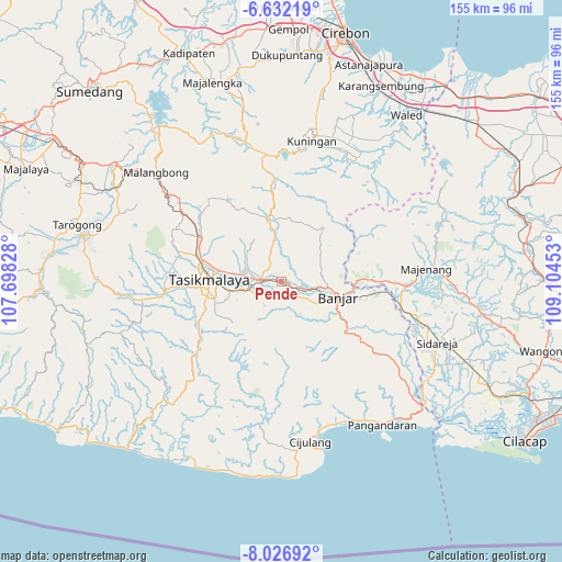
Pende GPS coordinates[2]
7° 19' 48.36" South, 108° 24' 5.04" East
| Map corner | latitude | longitude |
|---|---|---|
| Upper-left | -6.63219°, | 107.69828° |
| Center: | -7.3301°, | 108.4014° |
| Lower-right: | -8.02692°, | 109.10453° |
| Map W x H: | 155.1×155.1 km | = 96.4×96.4mi |
| max Lat: | 5.88969° ⇑50.3% North |
| Pende: | -7.3301° |
| min Lat: | ⇓49.7% South -10.934° |
| min Long | Pende | max Long |
| 95.1345° | 108.4014° | 140.9419° |
| W 27.1%⇐ | ⇒72.9% E |
Elevation
Elevation of Pende is 144 m = 472 ft, and this is 85.7 m = 281 ft below average elevation for this country.
| Max E: |
3185 m = 10449 ft | 42.2% |
| Avg. | 229.7 m = 754 ft | |
| Pende | 144 m = 472 ft | |
Min E: |
-1 m = -3 ft | 57.8% |
See also: Indonesia elevation on elevation.city.
Geographical zone
Pende is located in South Torrid zone (between Equator and Tropic of Capricorn). Distance of Equator is 815 km =506.4 mi to North.| Distance of | km | miles | from Pende |
|---|---|---|---|
| Equator | 815 | 506.4 | to North |
| Tropic Capricorn | 1790.9 | 1112.8 | to South |
| Antarctic Circle | 6586.1 | 4092.4 | to South |
| South Pole | 9192 | 5711.6 | to South |


Nearby cities:
15 places around Pende: (largest is in red/bold)
• Ancol
4.2 km =2.6 mi,  202°
202°
• Bojong
3.8 km =2.4 mi,  118°
118°
• Ciharalang
2.5 km =1.6 mi,  154°
154°
• Cijeungjing
1.5 km =0.9 mi,  99°
99°
• Cijeungjing Kaler
2 km =1.2 mi,  106°
106°
• Desa Cigembor
3.8 km =2.4 mi,  251°
251°
• Desa Kertasari
3.6 km =2.2 mi,  275°
275°
• Desa Sukamaju
4 km =2.5 mi,  306°
306°
• Dewasari
1.7 km =1.1 mi,  256°
256°
• Dusun Desa Handapherang
2.8 km =1.7 mi,  239°
239°
• Karanganyar
3.4 km =2.1 mi,  39°
39°
• Kertabumi
4.1 km =2.5 mi, 97°
• Kertaharja
2.2 km =1.4 mi,  342°
342°
• Lawong
4.2 km =2.6 mi, 338°
• Utama Wetan
2.3 km =1.4 mi,  293°
293°
Sources, notices
• [Note1] Compared only with cities in Indonesia existing in our database
• [Src1] Map data: © OpenStreetMap contributors (CC-BY-SA)
• [Src2] Other city data from geonames.org with taken over terms of usage.
• [Src3] Geographical zone / Annual Mean Temperature by Robert A. Rohde @ Wikipedia
