Nangka geodata
Nangka (West Java) is a seat of a fourth-order administrative division; located in Indonesia in Asia/Jakarta (GMT+7) time zone. In our database, there are 407 cities with bigger population. Compared to other cities in Indonesia, 65.4% of cities are located further ↓South; 71.9% of cities are located further →East and 88.3% of cities have lower elevation than Nangka. Note1


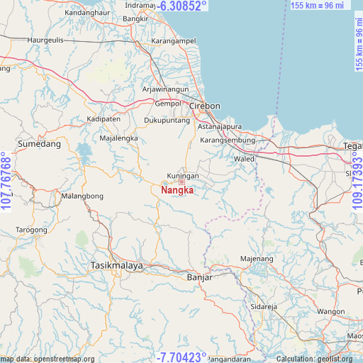
Nangka GPS coordinates[2]
7° 0' 24.84" South, 108° 28' 14.88" East
| Map corner | latitude | longitude |
|---|---|---|
| Upper-left | -6.30852°, | 107.76768° |
| Center: | -7.0069°, | 108.4708° |
| Lower-right: | -7.70423°, | 109.17393° |
| Map W x H: | 155.2×155.2 km | = 96.4×96.4mi |
| max Lat: | 5.88969° ⇑34.6% North |
| Nangka: | -7.0069° |
| min Lat: | ⇓65.4% South -10.934° |
| min Long | Nangka | max Long |
| 95.1345° | 108.4708° | 140.9419° |
| W 28.1%⇐ | ⇒71.9% E |
Elevation
Elevation of Nangka is 591 m = 1939 ft, and this is 361.3 m = 1185 ft above average elevation for this country.
| Max E: |
3185 m = 10449 ft | 11.7% |
| Nangka | 591 m 1939 ft | |
| Avg. | 229.7 m = 754 ft | |
Min E: |
-1 m = -3 ft | 88.3% |
See also: Indonesia elevation on elevation.city.
Geographical zone
Nangka is located in South Torrid zone (between Equator and Tropic of Capricorn). Distance of Equator is 779.1 km =484.1 mi to North.| Distance of | km | miles | from Nangka |
|---|---|---|---|
| Equator | 779.1 | 484.1 | to North |
| Tropic Capricorn | 1826.8 | 1135.1 | to South |
| Antarctic Circle | 6622.1 | 4114.8 | to South |
| South Pole | 9228 | 5734 | to South |


Nearby cities:
15 places around Nangka: (largest is in red/bold)
• Babatan
1.9 km =1.2 mi,  288°
288°
• Ciketak
1.4 km =0.9 mi,  253°
253°
• Haurkuning
4.6 km =2.9 mi, 253°
• Kadugede
1.8 km =1.1 mi,  279°
279°
• Kertayuga
4.5 km =2.8 mi,  235°
235°
• Kuningan
3.7 km =2.3 mi,  21°
21°
• Munggang
2 km =1.2 mi,  153°
153°
• Mungkaldatar
2.4 km =1.5 mi,  128°
128°
• Nusaherang
2.9 km =1.8 mi,  264°
264°
• Pakapasan Girang
4.5 km =2.8 mi,  190°
190°
• Rambatan
3.2 km =2 mi,  144°
144°
• Sindangjawa
3.2 km =2 mi,  216°
216°
• Tarikolot
4.5 km =2.8 mi,  112°
112°
• Tembong
4.7 km =2.9 mi,  85°
85°
• Windusari
3.1 km =1.9 mi, 243°
Sources, notices
• [Note1] Compared only with cities in Indonesia existing in our database
• [Src1] Map data: © OpenStreetMap contributors (CC-BY-SA)
• [Src2] Other city data from geonames.org with taken over terms of usage.
• [Src3] Geographical zone / Annual Mean Temperature by Robert A. Rohde @ Wikipedia
